Nerl’ geodata
Nerl’ (Tver’ Oblast) is a populated place; located in Russia in Europe/Moscow (GMT+3) time zone. With population of 774 people, there are 4775 cities with bigger population in this country. Compared to other cities in Russia, 77.6% of cities are located further ↓South; 77.4% of cities are located further →East and 63.5% of cities have higher elevation than Nerl’. Note1


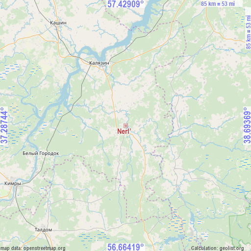
Nerl’ GPS coordinates[2]
57° 2' 54.996" North, 37° 59' 26.016" East
| Map corner | latitude | longitude |
|---|---|---|
| Upper-left | 57.42909°, | 37.28744° |
| Center: | 57.04861°, | 37.99056° |
| Lower-right: | 56.66419°, | 38.69369° |
| Map W x H: | 85×85 km | = 52.8×52.8mi |
| max Lat: | 73.50819° ⇑22.4% North |
| Nerl’: | 57.04861° |
| min Lat: | ⇓77.6% South 41.28413° |
| min Long | Nerl’ | max Long |
| -179.12198° | 37.99056° | 179.35046° |
| W 22.6%⇐ | ⇒77.4% E |
Elevation
Elevation of Nerl’ is 117 m = 384 ft, and this is 85.6 m = 281 ft below average elevation for this country.
| Max E: |
2518 m = 8261 ft | 63.5% |
| Avg. | 202.6 m = 665 ft | |
| Nerl’ | 117 m = 384 ft | |
Min E: |
-28 m = -92 ft | 36.5% |
See also: Russia elevation on elevation.city.
Geographical zone
Nerl’ is located in North temperate zone (between Tropic of Cancer and the Arctic Circle). Distance of this North polar circle is 1058 km =657.4 mi to North.| Distance of | km | miles | from Nerl’ |
|---|---|---|---|
| North Pole | 3663.9 | 2276.6 | to North |
| Arctic Circle | 1058 | 657.4 | to North |
| Tropic Cancer | 3737.3 | 2322.2 | to South |
| Equator | 6343.2 | 3941.5 | to South |


Nearby cities:
15 places around Nerl’: (largest is in red/bold)
• Belyy Gorodok
30.4 km =18.9 mi,  252°
252°
• Bogorodskoye
55.8 km =34.7 mi,  186°
186°
• Il’inskoye
49.7 km =30.9 mi,  259°
259°
• Kalyazin
23.1 km =14.4 mi,  337°
337°
• Kashin
41.5 km =25.8 mi,  326°
326°
• Kimry
43.8 km =27.2 mi,  242°
242°
• Konstantinovo
55.5 km =34.5 mi,  177°
177°
• Kvashenki
38.5 km =23.9 mi,  224°
224°
• Leont’yevskoye
22.3 km =13.9 mi,  3°
3°
• Pavlovichi
56.4 km =35 mi,  198°
198°
• Severnyy
40.7 km =25.3 mi,  210°
210°
• Shaburnovo
55.5 km =34.5 mi, 183°
• Taldom
44.7 km =27.8 mi, 218°
• Vinogradovo
29.6 km =18.4 mi, 244°
• Yurkino
42.3 km =26.3 mi, 214°
Sources, notices
• [Note1] Compared only with cities in Russia existing in our database
• [Src1] Map data: © OpenStreetMap contributors (CC-BY-SA)
• [Src2] Other city data from geonames.org with taken over terms of usage.
• [Src3] Geographical zone / Annual Mean Temperature by Robert A. Rohde @ Wikipedia
