Narimanov geodata
Narimanov (Astrakhan) is a populated place; located in Russia in Europe/Astrakhan (GMT+4) time zone. With population of 11,905 people, there are 1289 cities with bigger population in this country. Compared to other cities in Russia, 82.7% of cities are located further ↑North; 58.4% of cities are located further ←West and 99.6% of cities have higher elevation than Narimanov. Note1


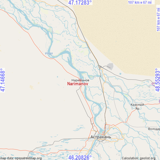
Narimanov GPS coordinates[2]
46° 41' 33.72" North, 47° 50' 59.28" East
| Map corner | latitude | longitude |
|---|---|---|
| Upper-left | 47.17283°, | 47.14668° |
| Center: | 46.6927°, | 47.8498° |
| Lower-right: | 46.20826°, | 48.55293° |
| Map W x H: | 107.3×107.2 km | = 66.7×66.6mi |
| max Lat: | 73.50819° ⇑82.7% North |
| Narimanov: | 46.6927° |
| min Lat: | ⇓17.3% South 41.28413° |
| min Long | Narimanov | max Long |
| -179.12198° | 47.8498° | 179.35046° |
| W 58.4%⇐ | ⇒41.6% E |
Elevation
Elevation of Narimanov is -22 m = -72 ft, and this is 224.6 m = 737 ft below average elevation for this country.
| Max E: |
2518 m = 8261 ft | 99.6% |
| Avg. | 202.6 m = 665 ft | |
| Narimanov | -22 m = -72 ft | |
Min E: |
-28 m = -92 ft | 0.4% |
See also: Russia elevation on elevation.city.
Geographical zone
Narimanov is located in North temperate zone (between Tropic of Cancer and the Arctic Circle). Distance of this North polar circle is 2209.4 km =1372.9 mi to North.| Distance of | km | miles | from Narimanov |
|---|---|---|---|
| North Pole | 4815.3 | 2992.1 | to North |
| Arctic Circle | 2209.4 | 1372.9 | to North |
| Tropic Cancer | 2585.8 | 1606.7 | to South |
| Equator | 5191.7 | 3226 | to South |


Nearby cities:
15 places around Narimanov: (largest is in red/bold)
• Aksarayskiy
16.6 km =10.3 mi,  48°
48°
• Altynzhar
68.4 km =42.5 mi,  132°
132°
• Astrakhan
40.8 km =25.4 mi,  159°
159°
• Ikryanoye
67.3 km =41.8 mi,  187°
187°
• Kamyzyak
67 km =41.6 mi,  165°
165°
• Krasnyy Yar
41.8 km =26 mi,  115°
115°
• Krasnyye Barrikady
54.3 km =33.7 mi,  179°
179°
• Mirnyy
35.5 km =22.1 mi, 171°
• Nachalovo
47.7 km =29.6 mi,  145°
145°
• Solyanka
36.1 km =22.4 mi, 159°
• Starokucherganovka
41.7 km =25.9 mi, 168°
• Tumak
71.6 km =44.5 mi,  135°
135°
• Volgo-Kaspiyskiy
54.7 km =34 mi, 174°
• Volodarskiy
62 km =38.5 mi, 121°
• Yaksatovo
51.5 km =32 mi, 165°
Sources, notices
• [Note1] Compared only with cities in Russia existing in our database
• [Src1] Map data: © OpenStreetMap contributors (CC-BY-SA)
• [Src2] Other city data from geonames.org with taken over terms of usage.
• [Src3] Geographical zone / Annual Mean Temperature by Robert A. Rohde @ Wikipedia
