Medvedevo geodata
Medvedevo (Mariy-El Republic) is a populated place; located in Russia in Europe/Moscow (GMT+3) time zone. With population of 16,407 people, there are 1020 cities with bigger population in this country. Compared to other cities in Russia, 73.8% of cities are located further ↓South; 58.3% of cities are located further ←West and 65% of cities have higher elevation than Medvedevo. Note1


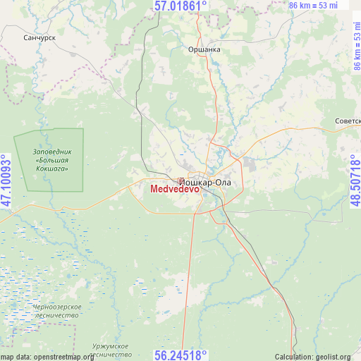
Medvedevo GPS coordinates[2]
56° 38' 1.968" North, 47° 48' 14.58" East
| Map corner | latitude | longitude |
|---|---|---|
| Upper-left | 57.01861°, | 47.10093° |
| Center: | 56.63388°, | 47.80405° |
| Lower-right: | 56.24518°, | 48.50718° |
| Map W x H: | 86×86 km | = 53.4×53.4mi |
| max Lat: | 73.50819° ⇑26.2% North |
| Medvedevo: | 56.63388° |
| min Lat: | ⇓73.8% South 41.28413° |
| min Long | Medvedevo | max Long |
| -179.12198° | 47.80405° | 179.35046° |
| W 58.3%⇐ | ⇒41.7% E |
Elevation
Elevation of Medvedevo is 114 m = 374 ft, and this is 88.6 m = 291 ft below average elevation for this country.
| Max E: |
2518 m = 8261 ft | 65% |
| Avg. | 202.6 m = 665 ft | |
| Medvedevo | 114 m = 374 ft | |
Min E: |
-28 m = -92 ft | 35% |
See also: Russia elevation on elevation.city.
Geographical zone
Medvedevo is located in North temperate zone (between Tropic of Cancer and the Arctic Circle). Distance of this North polar circle is 1104.1 km =686.1 mi to North.| Distance of | km | miles | from Medvedevo |
|---|---|---|---|
| North Pole | 3710 | 2305.3 | to North |
| Arctic Circle | 1104.1 | 686.1 | to North |
| Tropic Cancer | 3691.2 | 2293.6 | to South |
| Equator | 6297.1 | 3912.8 | to South |


Nearby cities:
15 places around Medvedevo: (largest is in red/bold)
• Atlashevo
70.8 km =44 mi,  192°
192°
• Cheboksary
65.3 km =40.6 mi,  211°
211°
• Kilemary
59.5 km =37 mi,  285°
285°
• Krasnogorskiy
62.4 km =38.8 mi,  149°
149°
• Kuzhener
70.5 km =43.8 mi,  73°
73°
• Mariinskiy Posad
57.9 km =36 mi, 185°
• Mochalishche
47.8 km =29.7 mi,  134°
134°
• Novocheboksarsk
61.5 km =38.2 mi,  199°
199°
• Novyye Lapsary
72.6 km =45.1 mi, 210°
• Orshanka
31.8 km =19.8 mi,  9°
9°
• Sanchursk
48 km =29.8 mi,  315°
315°
• Sovetskiy
43.3 km =26.9 mi, 71°
• Surok
28.5 km =17.7 mi,  136°
136°
• Suslonger
44.9 km =27.9 mi, 142°
• Yoshkar-Ola
5.3 km =3.3 mi,  84°
84°
Sources, notices
• [Note1] Compared only with cities in Russia existing in our database
• [Src1] Map data: © OpenStreetMap contributors (CC-BY-SA)
• [Src2] Other city data from geonames.org with taken over terms of usage.
• [Src3] Geographical zone / Annual Mean Temperature by Robert A. Rohde @ Wikipedia
