Mariinskiy Posad geodata
Mariinskiy Posad (Chuvashia) is a populated place; located in Russia in Europe/Moscow (GMT+3) time zone. With population of 10,199 people, there are 1480 cities with bigger population in this country. Compared to other cities in Russia, 68.1% of cities are located further ↓South; 58.1% of cities are located further ←West and 75.8% of cities have higher elevation than Mariinskiy Posad. Note1


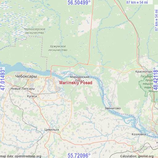
Mariinskiy Posad GPS coordinates[2]
56° 6' 53.892" North, 47° 43' 4.98" East
| Map corner | latitude | longitude |
|---|---|---|
| Upper-left | 56.50499°, | 47.01493° |
| Center: | 56.11497°, | 47.71805° |
| Lower-right: | 55.72096°, | 48.42118° |
| Map W x H: | 87.2×87.2 km | = 54.2×54.2mi |
| max Lat: | 73.50819° ⇑31.9% North |
| Mariinskiy Posad: | 56.11497° |
| min Lat: | ⇓68.1% South 41.28413° |
| min Long | Mariinskiy Posa | max Long |
| -179.12198° | 47.71805° | 179.35046° |
| W 58.1%⇐ | ⇒41.9% E |
Elevation
Elevation of Mariinskiy Posad is 85 m = 279 ft, and this is 117.6 m = 386 ft below average elevation for this country.
| Max E: |
2518 m = 8261 ft | 75.8% |
| Avg. | 202.6 m = 665 ft | |
| Mariinskiy Posad | 85 m = 279 ft | |
Min E: |
-28 m = -92 ft | 24.2% |
See also: Russia elevation on elevation.city.
Geographical zone
Mariinskiy Posad is located in North temperate zone (between Tropic of Cancer and the Arctic Circle). Distance of this North polar circle is 1161.8 km =721.9 mi to North.| Distance of | km | miles | from Mariinskiy Posad |
|---|---|---|---|
| North Pole | 3767.7 | 2341.1 | to North |
| Arctic Circle | 1161.8 | 721.9 | to North |
| Tropic Cancer | 3633.5 | 2257.8 | to South |
| Equator | 6239.4 | 3877 | to South |


Nearby cities:
15 places around Mariinskiy Posad: (largest is in red/bold)
• Atlashevo
15.2 km =9.4 mi,  221°
221°
• Cheboksary
29 km =18 mi,  273°
273°
• Ishley
42.7 km =26.5 mi,  256°
256°
• Kozlovka
44.8 km =27.8 mi,  132°
132°
• Krasnogorskiy
37.9 km =23.5 mi,  83°
83°
• Kugesi
28.1 km =17.5 mi,  250°
250°
• Mochalishche
46.1 km =28.6 mi,  58°
58°
• Novocheboksarsk
14.9 km =9.3 mi, 268°
• Novyye Lapsary
31.7 km =19.7 mi, 260°
• Pomary
42.6 km =26.5 mi,  112°
112°
• Surok
44.5 km =27.7 mi,  33°
33°
• Suslonger
39.9 km =24.8 mi, 56°
• Tsivil’sk
31.1 km =19.3 mi,  208°
208°
• Yantikovo
34.7 km =21.6 mi,  159°
159°
• Zvenigovo
24 km =14.9 mi, 130°
Sources, notices
• [Note1] Compared only with cities in Russia existing in our database
• [Src1] Map data: © OpenStreetMap contributors (CC-BY-SA)
• [Src2] Other city data from geonames.org with taken over terms of usage.
• [Src3] Geographical zone / Annual Mean Temperature by Robert A. Rohde @ Wikipedia
