Malakhovka geodata
Malakhovka (Moscow Oblast) is a populated place; located in Russia in Europe/Moscow (GMT+3) time zone. With population of 18,399 people, there are 937 cities with bigger population in this country. Compared to other cities in Russia, 60.7% of cities are located further ↓South; 77.1% of cities are located further →East and 53.6% of cities have higher elevation than Malakhovka. Note1


Malakhovka GPS coordinates[2]
55° 38' 51.936" North, 38° 1' 29.496" East
| Map corner | latitude | longitude |
|---|---|---|
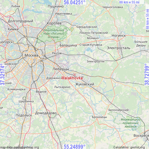
| Upper-left | 56.04251°, | 37.32174° |
| Center: | 55.64776°, | 38.02486° |
| Lower-right: | 55.24899°, | 38.72799° |
| Map W x H: | 88.2×88.2 km | = 54.8×54.8mi |
| max Lat: | 73.50819° ⇑39.3% North |
| Malakhovka: | 55.64776° |
| min Lat: | ⇓60.7% South 41.28413° |
| min Long | Malakhovka | max Long |
| -179.12198° | 38.02486° | 179.35046° |
| W 22.9%⇐ | ⇒77.1% E |
Elevation
Elevation of Malakhovka is 137 m = 449 ft, and this is 65.6 m = 215 ft below average elevation for this country.
| Max E: |
2518 m = 8261 ft | 53.6% |
| Avg. | 202.6 m = 665 ft | |
| Malakhovka | 137 m = 449 ft | |
Min E: |
-28 m = -92 ft | 46.4% |
See also: Russia elevation on elevation.city.
Geographical zone
Malakhovka is located in North temperate zone (between Tropic of Cancer and the Arctic Circle). Distance of this North polar circle is 1213.7 km =754.2 mi to North.| Distance of | km | miles | from Malakhovka |
|---|---|---|---|
| North Pole | 3819.6 | 2373.4 | to North |
| Arctic Circle | 1213.7 | 754.2 | to North |
| Tropic Cancer | 3581.5 | 2225.4 | to South |
| Equator | 6187.5 | 3844.7 | to South |


Nearby cities:
15 places around Malakhovka: (largest is in red/bold)
• Bykovo
3.7 km =2.3 mi,  110°
110°
• Bykovo
4.6 km =2.9 mi,  131°
131°
• Il’inskiy
6.7 km =4.2 mi,  118°
118°
• Korenëvo
2.9 km =1.8 mi,  338°
338°
• Kraskovo
2.3 km =1.4 mi,  275°
275°
• Nekrasovka
8.7 km =5.4 mi,  305°
305°
• Novyy Milet
7 km =4.3 mi,  17°
17°
• Oktyabr’skiy
5.3 km =3.3 mi,  214°
214°
• Ostrovtsy
6.8 km =4.2 mi,  190°
190°
• Purshevo
8.2 km =5.1 mi,  3°
3°
• Rodniki
2.7 km =1.7 mi,  79°
79°
• Tomilino
5 km =3.1 mi, 280°
• Udel’naya
2.8 km =1.7 mi, 209°
• Vereya
3.8 km =2.4 mi,  166°
166°
• Zhukovskiy
8.4 km =5.2 mi, 134°
Sources, notices
• [Note1] Compared only with cities in Russia existing in our database
• [Src1] Map data: © OpenStreetMap contributors (CC-BY-SA)
• [Src2] Other city data from geonames.org with taken over terms of usage.
• [Src3] Geographical zone / Annual Mean Temperature by Robert A. Rohde @ Wikipedia
