Kurdzhinovo geodata
Kurdzhinovo (Karachayevo-Cherkesiya Republic) is a populated place; located in Russia in Europe/Moscow (GMT+3) time zone. With population of 4,234 people, there are 2981 cities with bigger population in this country. Compared to other cities in Russia, 91.9% of cities are located further ↑North; 63.3% of cities are located further →East and 97.5% of cities have lower elevation than Kurdzhinovo. Note1


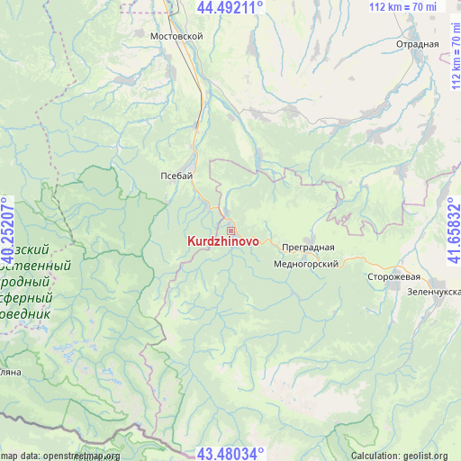
Kurdzhinovo GPS coordinates[2]
43° 59' 18.168" North, 40° 57' 18.684" East
| Map corner | latitude | longitude |
|---|---|---|
| Upper-left | 44.49211°, | 40.25207° |
| Center: | 43.98838°, | 40.95519° |
| Lower-right: | 43.48034°, | 41.65832° |
| Map W x H: | 112.5×112.5 km | = 69.9×69.9mi |
| max Lat: | 73.50819° ⇑91.9% North |
| Kurdzhinovo: | 43.98838° |
| min Lat: | ⇓8.1% South 41.28413° |
| min Long | Kurdzhinovo | max Long |
| -179.12198° | 40.95519° | 179.35046° |
| W 36.7%⇐ | ⇒63.3% E |
Elevation
Elevation of Kurdzhinovo is 810 m = 2657 ft, and this is 607.4 m = 1993 ft above average elevation for this country.
| Max E: |
2518 m = 8261 ft | 2.5% |
| Kurdzhinovo | 810 m 2657 ft | |
| Avg. | 202.6 m = 665 ft | |
Min E: |
-28 m = -92 ft | 97.5% |
See also: Russia elevation on elevation.city.
Geographical zone
Kurdzhinovo is located in North temperate zone (between Tropic of Cancer and the Arctic Circle). Distance of this Northern Tropic circle is 2285.1 km =1419.9 mi to South.| Distance of | km | miles | from Kurdzhinovo |
|---|---|---|---|
| North Pole | 5116 | 3178.9 | to North |
| Arctic Circle | 2510.1 | 1559.7 | to North |
| Tropic Cancer | 2285.1 | 1419.9 | to South |
| Equator | 4891 | 3039.1 | to South |


Nearby cities:
15 places around Kurdzhinovo: (largest is in red/bold)
• Besleneyevskaya
32.6 km =20.3 mi,  325°
325°
• Gubskaya
44.5 km =27.7 mi, 325°
• Ispravnaya
53.1 km =33 mi,  80°
80°
• Mednogorskiy
19.8 km =12.3 mi,  113°
113°
• Mostovskoy
48.9 km =30.4 mi,  344°
344°
• Peredovaya
44 km =27.3 mi,  70°
70°
• Perepravnaya
41 km =25.5 mi, 340°
• Pregradnaya
19.1 km =11.9 mi,  101°
101°
• Psebay
18.9 km =11.7 mi,  322°
322°
• Shedok
26.9 km =16.7 mi, 341°
• Spokoynaya
45.8 km =28.5 mi,  51°
51°
• Storozhevaya
41.6 km =25.8 mi, 107°
• Udobnaya
52.9 km =32.9 mi,  64°
64°
• Upornaya
45.1 km =28 mi,  6°
6°
• Zelenchukskaya
52.8 km =32.8 mi, 105°
Sources, notices
• [Note1] Compared only with cities in Russia existing in our database
• [Src1] Map data: © OpenStreetMap contributors (CC-BY-SA)
• [Src2] Other city data from geonames.org with taken over terms of usage.
• [Src3] Geographical zone / Annual Mean Temperature by Robert A. Rohde @ Wikipedia
