Kratovo geodata
Kratovo (Moscow Oblast) is a populated place; located in Russia in Europe/Moscow (GMT+3) time zone. With population of 6,799 people, there are 2049 cities with bigger population in this country. Compared to other cities in Russia, 59.5% of cities are located further ↓South; 76% of cities are located further →East and 50.2% of cities have higher elevation than Kratovo. Note1


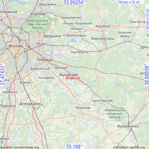
Kratovo GPS coordinates[2]
55° 35' 50.208" North, 38° 10' 38.748" East
| Map corner | latitude | longitude |
|---|---|---|
| Upper-left | 55.99254°, | 37.47431° |
| Center: | 55.59728°, | 38.17743° |
| Lower-right: | 55.198°, | 38.88056° |
| Map W x H: | 88.3×88.3 km | = 54.9×54.9mi |
| max Lat: | 73.50819° ⇑40.5% North |
| Kratovo: | 55.59728° |
| min Lat: | ⇓59.5% South 41.28413° |
| min Long | Kratovo | max Long |
| -179.12198° | 38.17743° | 179.35046° |
| W 24%⇐ | ⇒76% E |
Elevation
Elevation of Kratovo is 144 m = 472 ft, and this is 58.6 m = 192 ft below average elevation for this country.
| Max E: |
2518 m = 8261 ft | 50.2% |
| Avg. | 202.6 m = 665 ft | |
| Kratovo | 144 m = 472 ft | |
Min E: |
-28 m = -92 ft | 49.8% |
See also: Russia elevation on elevation.city.
Geographical zone
Kratovo is located in North temperate zone (between Tropic of Cancer and the Arctic Circle). Distance of this North polar circle is 1219.3 km =757.6 mi to North.| Distance of | km | miles | from Kratovo |
|---|---|---|---|
| North Pole | 3825.2 | 2376.9 | to North |
| Arctic Circle | 1219.3 | 757.6 | to North |
| Tropic Cancer | 3575.9 | 2222 | to South |
| Equator | 6181.8 | 3841.2 | to South |


Nearby cities:
15 places around Kratovo: (largest is in red/bold)
• Bykovo
6.7 km =4.2 mi,  293°
293°
• Bykovo
7.5 km =4.7 mi,  305°
305°
• Igumnovo
8.3 km =5.2 mi,  73°
73°
• Il’inskiy
4.4 km =2.7 mi,  303°
303°
• Korenëvo
13.5 km =8.4 mi, 307°
• Kraskovo
13.3 km =8.3 mi, 296°
• Malakhovka
11.1 km =6.9 mi, 300°
• Novoye Selo
4.7 km =2.9 mi,  166°
166°
• Oktyabr’skiy
12.6 km =7.8 mi,  275°
275°
• Ostrovtsy
10.9 km =6.8 mi,  264°
264°
• Ramenskoye
4.7 km =2.9 mi,  135°
135°
• Rodniki
9.2 km =5.7 mi, 311°
• Udel’naya
11.4 km =7.1 mi, 285°
• Vereya
8.9 km =5.5 mi, 282°
• Zhukovskiy
3.6 km =2.2 mi,  266°
266°
Sources, notices
• [Note1] Compared only with cities in Russia existing in our database
• [Src1] Map data: © OpenStreetMap contributors (CC-BY-SA)
• [Src2] Other city data from geonames.org with taken over terms of usage.
• [Src3] Geographical zone / Annual Mean Temperature by Robert A. Rohde @ Wikipedia
