Kozhukhovo geodata
Kozhukhovo (Moscow Oblast) is a section of populated place; located in Russia in Europe/Moscow (GMT+3) time zone. With population of 50,000 people, there are 416 cities with bigger population in this country. Compared to other cities in Russia, 61.5% of cities are located further ↓South; 80% of cities are located further →East and 62% of cities have higher elevation than Kozhukhovo. Note1


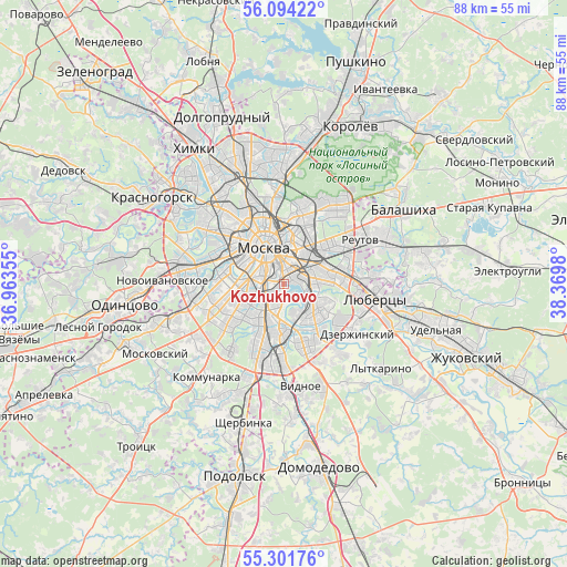
Kozhukhovo GPS coordinates[2]
55° 42' 0" North, 37° 40' 0.012" East
| Map corner | latitude | longitude |
|---|---|---|
| Upper-left | 56.09422°, | 36.96355° |
| Center: | 55.7°, | 37.66667° |
| Lower-right: | 55.30176°, | 38.3698° |
| Map W x H: | 88.1×88.1 km | = 54.7×54.7mi |
| max Lat: | 73.50819° ⇑38.5% North |
| Kozhukhovo: | 55.7° |
| min Lat: | ⇓61.5% South 41.28413° |
| min Long | Kozhukhovo | max Long |
| -179.12198° | 37.66667° | 179.35046° |
| W 20%⇐ | ⇒80% E |
Elevation
Elevation of Kozhukhovo is 120 m = 394 ft, and this is 82.6 m = 271 ft below average elevation for this country.
| Max E: |
2518 m = 8261 ft | 62% |
| Avg. | 202.6 m = 665 ft | |
| Kozhukhovo | 120 m = 394 ft | |
Min E: |
-28 m = -92 ft | 38% |
See also: Kozhukhovo elevation on elevation.city.
Geographical zone
Kozhukhovo is located in North temperate zone (between Tropic of Cancer and the Arctic Circle). Distance of this North polar circle is 1207.9 km =750.6 mi to North.| Distance of | km | miles | from Kozhukhovo |
|---|---|---|---|
| North Pole | 3813.8 | 2369.8 | to North |
| Arctic Circle | 1207.9 | 750.6 | to North |
| Tropic Cancer | 3587.3 | 2229 | to South |
| Equator | 6193.3 | 3848.3 | to South |


Nearby cities:
15 places around Kozhukhovo: (largest is in red/bold)
• Kolomenskoye
3.9 km =2.4 mi,  164°
164°
• Kotlovka
6 km =3.7 mi,  220°
220°
• Kur’yanovo
5.9 km =3.7 mi, 159°
• Leninskiye Gory
6.3 km =3.9 mi,  270°
270°
• Luzhniki
7.3 km =4.5 mi,  284°
284°
• Lyublino
6.4 km =4 mi,  113°
113°
• Mar’ino
6.4 km =4 mi,  150°
150°
• Moscow
6.6 km =4.1 mi,  331°
331°
• Nagornyy
6.4 km =4 mi,  209°
209°
• Novyye Cherëmushki
5.2 km =3.2 mi, 270°
• Novyye Kuz’minki
5.2 km =3.2 mi,  90°
90°
• Ryazanskiy
7.3 km =4.5 mi,  59°
59°
• Taganskiy
3.7 km =2.3 mi,  0°
0°
• Tekstil’shchiki
4.8 km =3 mi, 89°
• Zamoskvorech’ye
4.3 km =2.7 mi, 330°
Sources, notices
• [Note1] Compared only with cities in Russia existing in our database
• [Src1] Map data: © OpenStreetMap contributors (CC-BY-SA)
• [Src2] Other city data from geonames.org with taken over terms of usage.
• [Src3] Geographical zone / Annual Mean Temperature by Robert A. Rohde @ Wikipedia
