Kotlovka geodata
Kotlovka (Moscow) is a section of populated place; located in Russia in Europe/Moscow (GMT+3) time zone. With population of 64,000 people, there are 321 cities with bigger population in this country. Compared to other cities in Russia, 60.9% of cities are located further ↓South; 80.6% of cities are located further →East and 66.2% of cities have lower elevation than Kotlovka. Note1


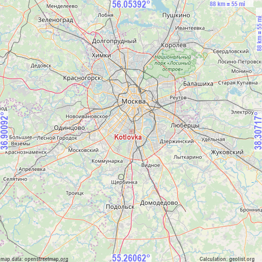
Kotlovka GPS coordinates[2]
55° 39' 33.408" North, 37° 36' 14.544" East
| Map corner | latitude | longitude |
|---|---|---|
| Upper-left | 56.05392°, | 36.90092° |
| Center: | 55.65928°, | 37.60404° |
| Lower-right: | 55.26062°, | 38.30717° |
| Map W x H: | 88.2×88.2 km | = 54.8×54.8mi |
| max Lat: | 73.50819° ⇑39.1% North |
| Kotlovka: | 55.65928° |
| min Lat: | ⇓60.9% South 41.28413° |
| min Long | Kotlovka | max Long |
| -179.12198° | 37.60404° | 179.35046° |
| W 19.4%⇐ | ⇒80.6% E |
Elevation
Elevation of Kotlovka is 185 m = 607 ft, and this is 17.6 m = 58 ft below average elevation for this country.
| Max E: |
2518 m = 8261 ft | 33.8% |
| Avg. | 202.6 m = 665 ft | |
| Kotlovka | 185 m = 607 ft | |
Min E: |
-28 m = -92 ft | 66.2% |
See also: Kotlovka elevation on elevation.city.
Geographical zone
Kotlovka is located in North temperate zone (between Tropic of Cancer and the Arctic Circle). Distance of this North polar circle is 1212.4 km =753.4 mi to North.| Distance of | km | miles | from Kotlovka |
|---|---|---|---|
| North Pole | 3818.3 | 2372.6 | to North |
| Arctic Circle | 1212.4 | 753.4 | to North |
| Tropic Cancer | 3582.8 | 2226.2 | to South |
| Equator | 6188.7 | 3845.5 | to South |


Nearby cities:
15 places around Kotlovka: (largest is in red/bold)
• Chertanovo Yuzhnoye
7.6 km =4.7 mi,  184°
184°
• Cherëmushki
2.7 km =1.7 mi,  282°
282°
• Kolomenskoye
5 km =3.1 mi,  80°
80°
• Kozhukhovo
6 km =3.7 mi,  40°
40°
• Kur’yanovo
6.1 km =3.8 mi,  99°
99°
• Leninskiye Gory
5.1 km =3.2 mi,  332°
332°
• Luzhniki
7 km =4.3 mi, 333°
• Mar’ino
7.1 km =4.4 mi, 98°
• Nagornyy
1.3 km =0.8 mi,  142°
142°
• Novyye Cherëmushki
4.7 km =2.9 mi,  343°
343°
• Orekhovo-Borisovo Severnoye
6.9 km =4.3 mi,  133°
133°
• Semënovskoye
4.3 km =2.7 mi,  308°
308°
• Troparëvo
7.5 km =4.7 mi,  267°
267°
• Tsaritsyno
4.8 km =3 mi, 142°
• Zyuzino
2.3 km =1.4 mi,  260°
260°
Sources, notices
• [Note1] Compared only with cities in Russia existing in our database
• [Src1] Map data: © OpenStreetMap contributors (CC-BY-SA)
• [Src2] Other city data from geonames.org with taken over terms of usage.
• [Src3] Geographical zone / Annual Mean Temperature by Robert A. Rohde @ Wikipedia
