Kislovodsk geodata
Kislovodsk (Stavropol’ Kray) is a populated place; located in Russia in Europe/Moscow (GMT+3) time zone. With population of 132,771 people, there are 149 cities with bigger population in this country. Compared to other cities in Russia, 92.3% of cities are located further ↑North; 57.7% of cities are located further →East and 97.6% of cities have lower elevation than Kislovodsk. Note1


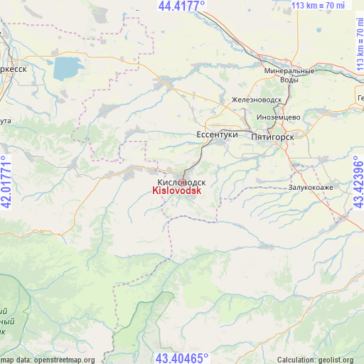
Kislovodsk GPS coordinates[2]
43° 54' 47.988" North, 42° 43' 14.988" East
| Map corner | latitude | longitude |
|---|---|---|
| Upper-left | 44.4177°, | 42.01771° |
| Center: | 43.91333°, | 42.72083° |
| Lower-right: | 43.40465°, | 43.42396° |
| Map W x H: | 112.6×112.6 km | = 70×70mi |
| max Lat: | 73.50819° ⇑92.3% North |
| Kislovodsk: | 43.91333° |
| min Lat: | ⇓7.7% South 41.28413° |
| min Long | Kislovodsk | max Long |
| -179.12198° | 42.72083° | 179.35046° |
| W 42.3%⇐ | ⇒57.7% E |
Elevation
Elevation of Kislovodsk is 815 m = 2674 ft, and this is 612.4 m = 2009 ft above average elevation for this country.
| Max E: |
2518 m = 8261 ft | 2.4% |
| Kislovodsk | 815 m 2674 ft | |
| Avg. | 202.6 m = 665 ft | |
Min E: |
-28 m = -92 ft | 97.6% |
See also: Kislovodsk elevation on elevation.city.
Geographical zone
Kislovodsk is located in North temperate zone (between Tropic of Cancer and the Arctic Circle). Distance of this Northern Tropic circle is 2276.8 km =1414.7 mi to South.| Distance of | km | miles | from Kislovodsk |
|---|---|---|---|
| North Pole | 5124.4 | 3184.2 | to North |
| Arctic Circle | 2518.5 | 1564.9 | to North |
| Tropic Cancer | 2276.8 | 1414.7 | to South |
| Equator | 4882.7 | 3034 | to South |


Nearby cities:
15 places around Kislovodsk: (largest is in red/bold)
• Borgustanskaya
22 km =13.7 mi,  315°
315°
• Etoka
26.2 km =16.3 mi,  88°
88°
• Krasnyy Kurgan
9.4 km =5.8 mi,  290°
290°
• Lermontov
29.5 km =18.3 mi,  43°
43°
• Nezhinskiy
3.3 km =2.1 mi,  300°
300°
• Novoblagodarnoye
28.4 km =17.6 mi,  25°
25°
• Pervomayskoye
19.8 km =12.3 mi,  278°
278°
• Svobody
29.2 km =18.1 mi,  64°
64°
• Tereze
22.4 km =13.9 mi, 276°
• Uchkeken
17 km =10.6 mi, 279°
• Vinsady
27 km =16.8 mi,  46°
46°
• Yasnaya Polyana
12.4 km =7.7 mi,  12°
12°
• Yessentuki
18.4 km =11.4 mi, 37°
• Yessentukskaya
18.5 km =11.5 mi, 44°
• Yutsa
23.9 km =14.9 mi,  78°
78°
Sources, notices
• [Note1] Compared only with cities in Russia existing in our database
• [Src1] Map data: © OpenStreetMap contributors (CC-BY-SA)
• [Src2] Other city data from geonames.org with taken over terms of usage.
• [Src3] Geographical zone / Annual Mean Temperature by Robert A. Rohde @ Wikipedia
