Tereze geodata
Tereze (Karachayevo-Cherkesiya Republic) is a populated place; located in Russia in Europe/Moscow (GMT+3) time zone. With population of 6,335 people, there are 2170 cities with bigger population in this country. Compared to other cities in Russia, 92.1% of cities are located further ↑North; 58.5% of cities are located further →East and 98.7% of cities have lower elevation than Tereze. Note1


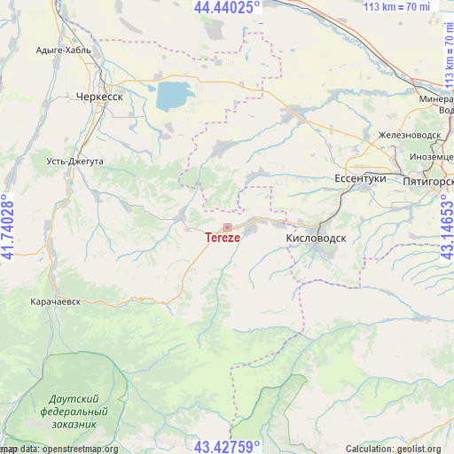
Tereze GPS coordinates[2]
43° 56' 9.888" North, 42° 26' 36.24" East
| Map corner | latitude | longitude |
|---|---|---|
| Upper-left | 44.44025°, | 41.74028° |
| Center: | 43.93608°, | 42.4434° |
| Lower-right: | 43.42759°, | 43.14653° |
| Map W x H: | 112.6×112.6 km | = 70×70mi |
| max Lat: | 73.50819° ⇑92.1% North |
| Tereze: | 43.93608° |
| min Lat: | ⇓7.9% South 41.28413° |
| min Long | Tereze | max Long |
| -179.12198° | 42.4434° | 179.35046° |
| W 41.5%⇐ | ⇒58.5% E |
Elevation
Elevation of Tereze is 1036 m = 3399 ft, and this is 833.4 m = 2734 ft above average elevation for this country.
| Max E: |
2518 m = 8261 ft | 1.3% |
| Tereze | 1036 m 3399 ft | |
| Avg. | 202.6 m = 665 ft | |
Min E: |
-28 m = -92 ft | 98.7% |
See also: Russia elevation on elevation.city.
Geographical zone
Tereze is located in North temperate zone (between Tropic of Cancer and the Arctic Circle). Distance of this Northern Tropic circle is 2279.3 km =1416.3 mi to South.| Distance of | km | miles | from Tereze |
|---|---|---|---|
| North Pole | 5121.8 | 3182.5 | to North |
| Arctic Circle | 2515.9 | 1563.3 | to North |
| Tropic Cancer | 2279.3 | 1416.3 | to South |
| Equator | 4885.2 | 3035.5 | to South |


Nearby cities:
15 places around Tereze: (largest is in red/bold)
• Bekeshevskaya
19.8 km =12.3 mi,  356°
356°
• Borgustanskaya
14.9 km =9.3 mi,  27°
27°
• Grazhdanskoye
41.8 km =26 mi,  38°
38°
• Kavkazskiy
40.4 km =25.1 mi,  335°
335°
• Kislovodsk
22.4 km =13.9 mi,  96°
96°
• Krasnyy Kurgan
13.4 km =8.3 mi,  87°
87°
• Nezhinskiy
19.4 km =12.1 mi, 92°
• Novoblagodarnoye
41.5 km =25.8 mi,  56°
56°
• Pervomayskoye
2.6 km =1.6 mi,  84°
84°
• Suvorovskaya
33.1 km =20.6 mi, 31°
• Uchkeken
5.5 km =3.4 mi, 88°
• Ust’-Dzheguta
40.8 km =25.4 mi,  293°
293°
• Yasnaya Polyana
26.6 km =16.5 mi,  68°
68°
• Yessentuki
35.5 km =22.1 mi, 70°
• Yessentukskaya
36.6 km =22.7 mi, 72°
Sources, notices
• [Note1] Compared only with cities in Russia existing in our database
• [Src1] Map data: © OpenStreetMap contributors (CC-BY-SA)
• [Src2] Other city data from geonames.org with taken over terms of usage.
• [Src3] Geographical zone / Annual Mean Temperature by Robert A. Rohde @ Wikipedia
