Khumalag geodata
Khumalag (North Ossetia) is a populated place; located in Russia in Europe/Moscow (GMT+3) time zone. With population of 3,906 people, there are 3166 cities with bigger population in this country. Compared to other cities in Russia, 95.9% of cities are located further ↑North; 51.7% of cities are located further →East and 89.4% of cities have lower elevation than Khumalag. Note1


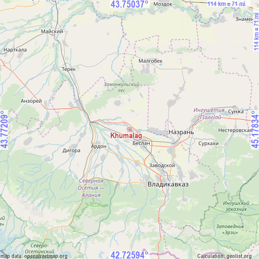
Khumalag GPS coordinates[2]
43° 14' 25.116" North, 44° 28' 30.756" East
| Map corner | latitude | longitude |
|---|---|---|
| Upper-left | 43.75037°, | 43.77209° |
| Center: | 43.24031°, | 44.47521° |
| Lower-right: | 42.72594°, | 45.17834° |
| Map W x H: | 113.9×113.9 km | = 70.8×70.8mi |
| max Lat: | 73.50819° ⇑95.9% North |
| Khumalag: | 43.24031° |
| min Lat: | ⇓4.1% South 41.28413° |
| min Long | Khumalag | max Long |
| -179.12198° | 44.47521° | 179.35046° |
| W 48.3%⇐ | ⇒51.7% E |
Elevation
Elevation of Khumalag is 441 m = 1447 ft, and this is 238.4 m = 782 ft above average elevation for this country.
| Max E: |
2518 m = 8261 ft | 10.6% |
| Khumalag | 441 m 1447 ft | |
| Avg. | 202.6 m = 665 ft | |
Min E: |
-28 m = -92 ft | 89.4% |
See also: Russia elevation on elevation.city.
Geographical zone
Khumalag is located in North temperate zone (between Tropic of Cancer and the Arctic Circle). Distance of this Northern Tropic circle is 2202 km =1368.3 mi to South.| Distance of | km | miles | from Khumalag |
|---|---|---|---|
| North Pole | 5199.2 | 3230.6 | to North |
| Arctic Circle | 2593.3 | 1611.4 | to North |
| Tropic Cancer | 2202 | 1368.3 | to South |
| Equator | 4807.9 | 2987.5 | to South |


Nearby cities:
15 places around Khumalag: (largest is in red/bold)
• Ardon
16.1 km =10 mi,  244°
244°
• Arkhonskaya
14.8 km =9.2 mi,  168°
168°
• Beslan
7.7 km =4.8 mi,  134°
134°
• Chermen
21.6 km =13.4 mi,  117°
117°
• Dachnoye
27.3 km =17 mi, 129°
• Dalakovo
9.3 km =5.8 mi,  91°
91°
• Gizel’
23.6 km =14.7 mi,  160°
160°
• Kantyshevo
12.9 km =8 mi,  95°
95°
• Kardzhin
15.4 km =9.6 mi,  283°
283°
• Magas
24.2 km =15 mi, 94°
• Mikhaylovskoye
20.1 km =12.5 mi,  140°
140°
• Nazran’
24.2 km =15 mi, 93°
• Nogir
22 km =13.7 mi, 143°
• Psedakh
26.3 km =16.3 mi,  16°
16°
• Verkhniye Achaluki
21.5 km =13.4 mi,  56°
56°
Sources, notices
• [Note1] Compared only with cities in Russia existing in our database
• [Src1] Map data: © OpenStreetMap contributors (CC-BY-SA)
• [Src2] Other city data from geonames.org with taken over terms of usage.
• [Src3] Geographical zone / Annual Mean Temperature by Robert A. Rohde @ Wikipedia
