Mikhaylovskoye geodata
Mikhaylovskoye (North Ossetia) is a populated place; located in Russia in Europe/Moscow (GMT+3) time zone. With population of 10,479 people, there are 1443 cities with bigger population in this country. Compared to other cities in Russia, 97.1% of cities are located further ↑North; 51.1% of cities are located further →East and 94.4% of cities have lower elevation than Mikhaylovskoye. Note1


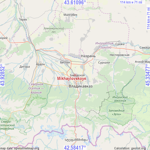
Mikhaylovskoye GPS coordinates[2]
43° 5' 58.992" North, 44° 37' 53.904" East
| Map corner | latitude | longitude |
|---|---|---|
| Upper-left | 43.61096°, | 43.92852° |
| Center: | 43.09972°, | 44.63164° |
| Lower-right: | 42.58417°, | 45.33477° |
| Map W x H: | 114.2×114.2 km | = 71×71mi |
| max Lat: | 73.50819° ⇑97.1% North |
| Mikhaylovskoye: | 43.09972° |
| min Lat: | ⇓2.9% South 41.28413° |
| min Long | Mikhaylovskoye | max Long |
| -179.12198° | 44.63164° | 179.35046° |
| W 48.9%⇐ | ⇒51.1% E |
Elevation
Elevation of Mikhaylovskoye is 605 m = 1985 ft, and this is 402.4 m = 1320 ft above average elevation for this country.
| Max E: |
2518 m = 8261 ft | 5.6% |
| Mikhaylovskoye | 605 m 1985 ft | |
| Avg. | 202.6 m = 665 ft | |
Min E: |
-28 m = -92 ft | 94.4% |
See also: Russia elevation on elevation.city.
Geographical zone
Mikhaylovskoye is located in North temperate zone (between Tropic of Cancer and the Arctic Circle). Distance of this Northern Tropic circle is 2186.3 km =1358.5 mi to South.| Distance of | km | miles | from Mikhaylovskoye |
|---|---|---|---|
| North Pole | 5214.8 | 3240.3 | to North |
| Arctic Circle | 2608.9 | 1621.1 | to North |
| Tropic Cancer | 2186.3 | 1358.5 | to South |
| Equator | 4792.2 | 2977.7 | to South |


Nearby cities:
15 places around Mikhaylovskoye: (largest is in red/bold)
• Ali-Yurt
18.5 km =11.5 mi,  75°
75°
• Arkhonskaya
9.7 km =6 mi,  276°
276°
• Beslan
12.5 km =7.8 mi,  325°
325°
• Chermen
8.7 km =5.4 mi,  48°
48°
• Dachnoye
8.6 km =5.3 mi,  101°
101°
• Dalakovo
15.7 km =9.8 mi,  347°
347°
• Gizel’
8.3 km =5.2 mi,  216°
216°
• Kambileyevskoye
10.1 km =6.3 mi, 103°
• Kantyshevo
14.3 km =8.9 mi,  0°
0°
• Magas
17.8 km =11.1 mi,  39°
39°
• Nazran’
18.1 km =11.2 mi, 39°
• Nogir
2.1 km =1.3 mi,  168°
168°
• Sunzha
16.2 km =10.1 mi,  106°
106°
• Tarskoye
18.9 km =11.7 mi,  141°
141°
• Vladikavkaz
7.6 km =4.7 mi,  157°
157°
Sources, notices
• [Note1] Compared only with cities in Russia existing in our database
• [Src1] Map data: © OpenStreetMap contributors (CC-BY-SA)
• [Src2] Other city data from geonames.org with taken over terms of usage.
• [Src3] Geographical zone / Annual Mean Temperature by Robert A. Rohde @ Wikipedia
