Khoroshëvo-Mnevniki geodata
Khoroshëvo-Mnevniki (Moscow Oblast) is a section of populated place; located in Russia in Europe/Moscow (GMT+3) time zone. With population of 159,000 people, there are 121 cities with bigger population in this country. Compared to other cities in Russia, 63.3% of cities are located further ↓South; 82.3% of cities are located further →East and 51.5% of cities have lower elevation than Khoroshëvo-Mnevniki. Note1


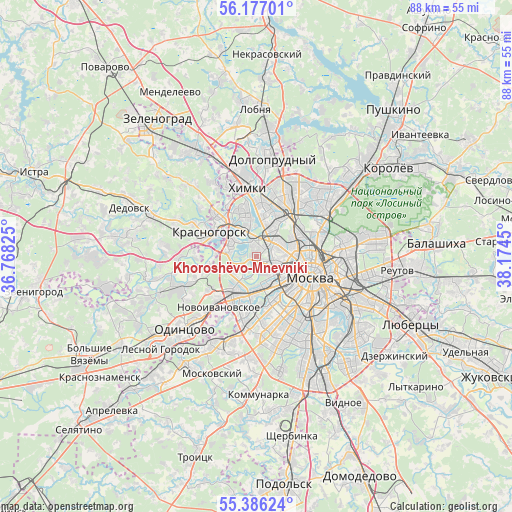
Khoroshëvo-Mnevniki GPS coordinates[2]
55° 47' 1.068" North, 37° 28' 16.932" East
| Map corner | latitude | longitude |
|---|---|---|
| Upper-left | 56.17701°, | 36.76825° |
| Center: | 55.78363°, | 37.47137° |
| Lower-right: | 55.38624°, | 38.1745° |
| Map W x H: | 87.9×87.9 km | = 54.6×54.6mi |
| max Lat: | 73.50819° ⇑36.7% North |
| Khoroshëvo-Mnevniki: | 55.78363° |
| min Lat: | ⇓63.3% South 41.28413° |
| min Long | Khoroshëvo-Mne | max Long |
| -179.12198° | 37.47137° | 179.35046° |
| W 17.7%⇐ | ⇒82.3% E |
Elevation
Elevation of Khoroshëvo-Mnevniki is 148 m = 486 ft, and this is 54.6 m = 179 ft below average elevation for this country.
| Max E: |
2518 m = 8261 ft | 48.5% |
| Avg. | 202.6 m = 665 ft | |
| Khoroshëvo-Mnevniki | 148 m = 486 ft | |
Min E: |
-28 m = -92 ft | 51.5% |
See also: Khoroshëvo-Mnevniki elevation on elevation.city.
Geographical zone
Khoroshëvo-Mnevniki is located in North temperate zone (between Tropic of Cancer and the Arctic Circle). Distance of this North polar circle is 1198.6 km =744.8 mi to North.| Distance of | km | miles | from Khoroshëvo-Mnevniki |
|---|---|---|---|
| North Pole | 3804.5 | 2364 | to North |
| Arctic Circle | 1198.6 | 744.8 | to North |
| Tropic Cancer | 3596.6 | 2234.8 | to South |
| Equator | 6202.6 | 3854.1 | to South |


Nearby cities:
15 places around Khoroshëvo-Mnevniki: (largest is in red/bold)
• Davydkovo
7.3 km =4.5 mi,  179°
179°
• Dorogomilovo
7 km =4.3 mi,  122°
122°
• Fili
4 km =2.5 mi,  172°
172°
• Golovinskiy
8 km =5 mi,  11°
11°
• Kastanayevo
7.7 km =4.8 mi, 166°
• Koptëvo
4.6 km =2.9 mi,  37°
37°
• Levoberezhnyy
7.4 km =4.6 mi, 5°
• Matveyevskoye
8.1 km =5 mi, 178°
• Pokrovskoye-Streshnëvo
2.8 km =1.7 mi,  343°
343°
• Presnenskiy
6.2 km =3.9 mi,  127°
127°
• Rublëvo
7.3 km =4.5 mi,  271°
271°
• Setun’
8.2 km =5.1 mi,  204°
204°
• Shchukino
2.3 km =1.4 mi,  323°
323°
• Sokol
3.4 km =2.1 mi,  57°
57°
• Strogino
5.3 km =3.3 mi, 316°
Sources, notices
• [Note1] Compared only with cities in Russia existing in our database
• [Src1] Map data: © OpenStreetMap contributors (CC-BY-SA)
• [Src2] Other city data from geonames.org with taken over terms of usage.
• [Src3] Geographical zone / Annual Mean Temperature by Robert A. Rohde @ Wikipedia
