Kevsala geodata
Kevsala (Stavropol’ Kray) is a populated place; located in Russia in Europe/Moscow (GMT+3) time zone. With population of 3,532 people, there are 3380 cities with bigger population in this country. Compared to other cities in Russia, 84.7% of cities are located further ↑North; 57.8% of cities are located further →East and 75% of cities have higher elevation than Kevsala. Note1


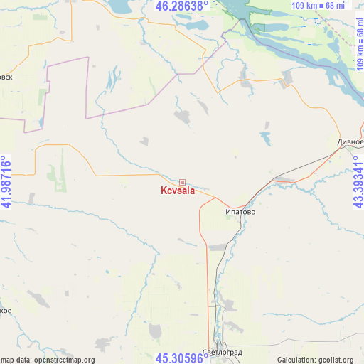
Kevsala GPS coordinates[2]
45° 47' 53.988" North, 42° 41' 25.008" East
| Map corner | latitude | longitude |
|---|---|---|
| Upper-left | 46.28638°, | 41.98716° |
| Center: | 45.79833°, | 42.69028° |
| Lower-right: | 45.30596°, | 43.39341° |
| Map W x H: | 109×109 km | = 67.7×67.7mi |
| max Lat: | 73.50819° ⇑84.7% North |
| Kevsala: | 45.79833° |
| min Lat: | ⇓15.3% South 41.28413° |
| min Long | Kevsala | max Long |
| -179.12198° | 42.69028° | 179.35046° |
| W 42.2%⇐ | ⇒57.8% E |
Elevation
Elevation of Kevsala is 88 m = 289 ft, and this is 114.6 m = 376 ft below average elevation for this country.
| Max E: |
2518 m = 8261 ft | 75% |
| Avg. | 202.6 m = 665 ft | |
| Kevsala | 88 m = 289 ft | |
Min E: |
-28 m = -92 ft | 25% |
See also: Russia elevation on elevation.city.
Geographical zone
Kevsala is located in North temperate zone (between Tropic of Cancer and the Arctic Circle). Distance of this North polar circle is 2308.9 km =1434.7 mi to North.| Distance of | km | miles | from Kevsala |
|---|---|---|---|
| North Pole | 4914.8 | 3053.9 | to North |
| Arctic Circle | 2308.9 | 1434.7 | to North |
| Tropic Cancer | 2486.4 | 1545 | to South |
| Equator | 5092.3 | 3164.2 | to South |


Nearby cities:
15 places around Kevsala: (largest is in red/bold)
• Bezopasnoye
60.9 km =37.8 mi,  254°
254°
• Blagodatnoye
45 km =28 mi,  190°
190°
• Divnoye
52.9 km =32.9 mi,  76°
76°
• Dmitriyevskoye
61.5 km =38.2 mi,  270°
270°
• Donskoye
67.5 km =41.9 mi,  235°
235°
• Gorodoviki
67.4 km =41.9 mi,  303°
303°
• Gorodovikovsk
66.8 km =41.5 mi, 298°
• Ipatovo
18.8 km =11.7 mi,  118°
118°
• Konstantinovskoye
55.7 km =34.6 mi,  184°
184°
• Letnyaya Stavka
71.7 km =44.6 mi, 124°
• Ovoshchi
68.8 km =42.8 mi,  134°
134°
• Priyutnoye
71.6 km =44.5 mi,  61°
61°
• Svetlograd
53.1 km =33 mi,  166°
166°
• Trunovskoye
55.2 km =34.3 mi,  231°
231°
• Yashalta
68.1 km =42.3 mi,  332°
332°
Sources, notices
• [Note1] Compared only with cities in Russia existing in our database
• [Src1] Map data: © OpenStreetMap contributors (CC-BY-SA)
• [Src2] Other city data from geonames.org with taken over terms of usage.
• [Src3] Geographical zone / Annual Mean Temperature by Robert A. Rohde @ Wikipedia
