Gorodoviki geodata
Gorodoviki (Kalmykiya Republic) is a populated place; located in Russia in Europe/Moscow (GMT+3) time zone. With population of 10,706 people, there are 1409 cities with bigger population in this country. Compared to other cities in Russia, 83.8% of cities are located further ↑North; 59.8% of cities are located further →East and 78.4% of cities have higher elevation than Gorodoviki. Note1


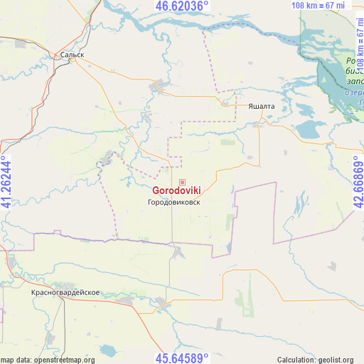
Gorodoviki GPS coordinates[2]
46° 8' 7.008" North, 41° 57' 56.016" East
| Map corner | latitude | longitude |
|---|---|---|
| Upper-left | 46.62036°, | 41.26244° |
| Center: | 46.13528°, | 41.96556° |
| Lower-right: | 45.64589°, | 42.66869° |
| Map W x H: | 108.4×108.3 km | = 67.4×67.3mi |
| max Lat: | 73.50819° ⇑83.8% North |
| Gorodoviki: | 46.13528° |
| min Lat: | ⇓16.2% South 41.28413° |
| min Long | Gorodoviki | max Long |
| -179.12198° | 41.96556° | 179.35046° |
| W 40.2%⇐ | ⇒59.8% E |
Elevation
Elevation of Gorodoviki is 76 m = 249 ft, and this is 126.6 m = 415 ft below average elevation for this country.
| Max E: |
2518 m = 8261 ft | 78.4% |
| Avg. | 202.6 m = 665 ft | |
| Gorodoviki | 76 m = 249 ft | |
Min E: |
-28 m = -92 ft | 21.6% |
See also: Russia elevation on elevation.city.
Geographical zone
Gorodoviki is located in North temperate zone (between Tropic of Cancer and the Arctic Circle). Distance of this North polar circle is 2271.4 km =1411.4 mi to North.| Distance of | km | miles | from Gorodoviki |
|---|---|---|---|
| North Pole | 4877.3 | 3030.6 | to North |
| Arctic Circle | 2271.4 | 1411.4 | to North |
| Tropic Cancer | 2523.8 | 1568.2 | to South |
| Equator | 5129.8 | 3187.5 | to South |


Nearby cities:
15 places around Gorodoviki: (largest is in red/bold)
• Bezopasnoye
54.2 km =33.7 mi,  182°
182°
• Dmitriyevskoye
37.1 km =23.1 mi,  188°
188°
• Gigant
63.2 km =39.3 mi,  310°
310°
• Gorodovikovsk
5.8 km =3.6 mi,  205°
205°
• Kevsala
67.4 km =41.9 mi,  123°
123°
• Krasnaya Polyana
35.8 km =22.2 mi,  266°
266°
• Krasnogvardeyskoye
47.2 km =29.3 mi,  227°
227°
• Letnik
55.7 km =34.6 mi,  255°
255°
• Novyy Yegorlyk
29.5 km =18.3 mi,  345°
345°
• Pregradnoye
38.7 km =24 mi, 205°
• Proletarsk
65.7 km =40.8 mi,  343°
343°
• Sal’sk
49.9 km =31 mi,  319°
319°
• Sandata
21.9 km =13.6 mi, 313°
• Sovetskoye
66.7 km =41.4 mi,  11°
11°
• Yashalta
33 km =20.5 mi,  46°
46°
Sources, notices
• [Note1] Compared only with cities in Russia existing in our database
• [Src1] Map data: © OpenStreetMap contributors (CC-BY-SA)
• [Src2] Other city data from geonames.org with taken over terms of usage.
• [Src3] Geographical zone / Annual Mean Temperature by Robert A. Rohde @ Wikipedia
