Dzhalka geodata
Dzhalka (Chechnya) is a populated place; located in Russia in Europe/Moscow (GMT+3) time zone. With population of 6,306 people, there are 2178 cities with bigger population in this country. Compared to other cities in Russia, 95.2% of cities are located further ↑North; 52.7% of cities are located further ←West and 76.1% of cities have higher elevation than Dzhalka. Note1


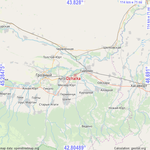
Dzhalka GPS coordinates[2]
43° 19' 6.96" North, 45° 59' 16.332" East
| Map corner | latitude | longitude |
|---|---|---|
| Upper-left | 43.828°, | 45.28475° |
| Center: | 43.3186°, | 45.98787° |
| Lower-right: | 42.80489°, | 46.691° |
| Map W x H: | 113.8×113.8 km | = 70.7×70.7mi |
| max Lat: | 73.50819° ⇑95.2% North |
| Dzhalka: | 43.3186° |
| min Lat: | ⇓4.8% South 41.28413° |
| min Long | Dzhalka | max Long |
| -179.12198° | 45.98787° | 179.35046° |
| W 52.7%⇐ | ⇒47.3% E |
Elevation
Elevation of Dzhalka is 84 m = 276 ft, and this is 118.6 m = 389 ft below average elevation for this country.
| Max E: |
2518 m = 8261 ft | 76.1% |
| Avg. | 202.6 m = 665 ft | |
| Dzhalka | 84 m = 276 ft | |
Min E: |
-28 m = -92 ft | 23.9% |
See also: Russia elevation on elevation.city.
Geographical zone
Dzhalka is located in North temperate zone (between Tropic of Cancer and the Arctic Circle). Distance of this Northern Tropic circle is 2210.7 km =1373.7 mi to South.| Distance of | km | miles | from Dzhalka |
|---|---|---|---|
| North Pole | 5190.5 | 3225.2 | to North |
| Arctic Circle | 2584.6 | 1606 | to North |
| Tropic Cancer | 2210.7 | 1373.7 | to South |
| Equator | 4816.6 | 2992.9 | to South |


Nearby cities:
15 places around Dzhalka: (largest is in red/bold)
• Argun
9.5 km =5.9 mi,  255°
255°
• Avtury
17.3 km =10.7 mi,  176°
176°
• Bachi-Yurt
19.7 km =12.2 mi,  122°
122°
• Belgatoy
19.1 km =11.9 mi,  221°
221°
• Germenchuk
15.7 km =9.8 mi,  200°
200°
• Gudermes
10.4 km =6.5 mi,  70°
70°
• Ilaskhan-Yurt
10.2 km =6.3 mi, 115°
• Khankala
18.9 km =11.7 mi, 264°
• Kurchaloy
15.3 km =9.5 mi,  147°
147°
• Mayrtup
17.3 km =10.7 mi,  137°
137°
• Mesker-Yurt
9.9 km =6.2 mi, 221°
• Petropavlovskaya
14.7 km =9.1 mi,  297°
297°
• Prigorodnoye
20 km =12.4 mi,  248°
248°
• Staraya Sunzha
19.8 km =12.3 mi,  275°
275°
• Tsotsin-Yurt
8.6 km =5.3 mi,  173°
173°
Sources, notices
• [Note1] Compared only with cities in Russia existing in our database
• [Src1] Map data: © OpenStreetMap contributors (CC-BY-SA)
• [Src2] Other city data from geonames.org with taken over terms of usage.
• [Src3] Geographical zone / Annual Mean Temperature by Robert A. Rohde @ Wikipedia
