Druzhnaya Gorka geodata
Druzhnaya Gorka (Leningradskaya Oblast') is a populated place; located in Russia in Europe/Moscow (GMT+3) time zone. With population of 3,677 people, there are 3288 cities with bigger population in this country. Compared to other cities in Russia, 87.2% of cities are located further ↓South; 96.7% of cities are located further →East and 74.6% of cities have higher elevation than Druzhnaya Gorka. Note1


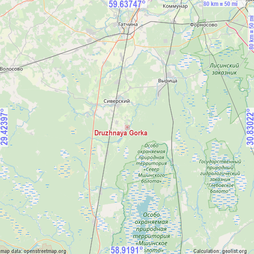
Druzhnaya Gorka GPS coordinates[2]
59° 16' 48.648" North, 30° 7' 37.524" East
| Map corner | latitude | longitude |
|---|---|---|
| Upper-left | 59.63747°, | 29.42397° |
| Center: | 59.28018°, | 30.12709° |
| Lower-right: | 58.9191°, | 30.83022° |
| Map W x H: | 79.9×79.9 km | = 49.6×49.6mi |
| max Lat: | 73.50819° ⇑12.8% North |
| Druzhnaya Gorka: | 59.28018° |
| min Lat: | ⇓87.2% South 41.28413° |
| min Long | Druzhnaya Gorka | max Long |
| -179.12198° | 30.12709° | 179.35046° |
| W 3.3%⇐ | ⇒96.7% E |
Elevation
Elevation of Druzhnaya Gorka is 89 m = 292 ft, and this is 113.6 m = 373 ft below average elevation for this country.
| Max E: |
2518 m = 8261 ft | 74.6% |
| Avg. | 202.6 m = 665 ft | |
| Druzhnaya Gorka | 89 m = 292 ft | |
Min E: |
-28 m = -92 ft | 25.4% |
See also: Russia elevation on elevation.city.
Geographical zone
Druzhnaya Gorka is located in North temperate zone (between Tropic of Cancer and the Arctic Circle). Distance of this North polar circle is 809.8 km =503.2 mi to North.| Distance of | km | miles | from Druzhnaya Gorka |
|---|---|---|---|
| North Pole | 3415.7 | 2122.4 | to North |
| Arctic Circle | 809.8 | 503.2 | to North |
| Tropic Cancer | 3985.4 | 2476.4 | to South |
| Equator | 6591.3 | 4095.6 | to South |


Nearby cities:
15 places around Druzhnaya Gorka: (largest is in red/bold)
• Fornosovo
40.2 km =25 mi,  36°
36°
• Gatchina
32.9 km =20.4 mi,  0°
0°
• Kikerino
35 km =21.7 mi,  305°
305°
• Kobrinskoye
15.8 km =9.8 mi,  359°
359°
• Kommunar
40.7 km =25.3 mi,  21°
21°
• Maloye Verevo
37.2 km =23.1 mi, 3°
• Mariyenburg
32.6 km =20.3 mi,  353°
353°
• Mshinskaya
31.3 km =19.4 mi,  199°
199°
• Rozhdestveno
11.1 km =6.9 mi,  292°
292°
• Siverskiy
8.7 km =5.4 mi,  341°
341°
• Taytsy
42.7 km =26.5 mi, 359°
• Volosovo
40.5 km =25.2 mi,  296°
296°
• Voyskovitsy
30.1 km =18.7 mi, 338°
• Vyritsa
18.9 km =11.7 mi, 41°
• Yelizavetino
30.6 km =19 mi,  320°
320°
Sources, notices
• [Note1] Compared only with cities in Russia existing in our database
• [Src1] Map data: © OpenStreetMap contributors (CC-BY-SA)
• [Src2] Other city data from geonames.org with taken over terms of usage.
• [Src3] Geographical zone / Annual Mean Temperature by Robert A. Rohde @ Wikipedia
