Bolgar geodata
Bolgar (Tatarstan Republic) is a populated place; located in Russia in Europe/Moscow (GMT+3) time zone. With population of 8,640 people, there are 1700 cities with bigger population in this country. Compared to other cities in Russia, 52.8% of cities are located further ↓South; 60.8% of cities are located further ←West and 80% of cities have higher elevation than Bolgar. Note1


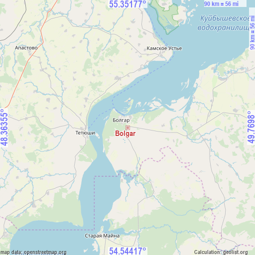
Bolgar GPS coordinates[2]
54° 57' 0" North, 49° 4' 0.012" East
| Map corner | latitude | longitude |
|---|---|---|
| Upper-left | 55.35177°, | 48.36355° |
| Center: | 54.95°, | 49.06667° |
| Lower-right: | 54.54417°, | 49.7698° |
| Map W x H: | 89.8×89.8 km | = 55.8×55.8mi |
| max Lat: | 73.50819° ⇑47.2% North |
| Bolgar: | 54.95° |
| min Lat: | ⇓52.8% South 41.28413° |
| min Long | Bolgar | max Long |
| -179.12198° | 49.06667° | 179.35046° |
| W 60.8%⇐ | ⇒39.2% E |
Elevation
Elevation of Bolgar is 71 m = 233 ft, and this is 131.6 m = 432 ft below average elevation for this country.
| Max E: |
2518 m = 8261 ft | 80% |
| Avg. | 202.6 m = 665 ft | |
| Bolgar | 71 m = 233 ft | |
Min E: |
-28 m = -92 ft | 20% |
See also: Russia elevation on elevation.city.
Geographical zone
Bolgar is located in North temperate zone (between Tropic of Cancer and the Arctic Circle). Distance of this North polar circle is 1291.3 km =802.4 mi to North.| Distance of | km | miles | from Bolgar |
|---|---|---|---|
| North Pole | 3897.2 | 2421.6 | to North |
| Arctic Circle | 1291.3 | 802.4 | to North |
| Tropic Cancer | 3503.9 | 2177.2 | to South |
| Equator | 6109.9 | 3796.5 | to South |


Nearby cities:
15 places around Bolgar: (largest is in red/bold)
• Alekseyevskoye
77.5 km =48.2 mi,  59°
59°
• Apastovo
45.2 km =28.1 mi,  308°
308°
• Bazarnyye Mataki
55.9 km =34.7 mi,  97°
97°
• Buinsk
49.5 km =30.8 mi,  272°
272°
• Cherdakly
67.2 km =41.8 mi,  192°
192°
• Isheyevka
77.5 km =48.2 mi,  221°
221°
• Kuybyshevskiy Zaton
24.2 km =15 mi,  15°
15°
• Laishevo
59.1 km =36.7 mi,  31°
31°
• Mirnyy
68.5 km =42.6 mi,  198°
198°
• Staraya Mayna
39.4 km =24.5 mi, 192°
• Stolbishchi
78 km =48.5 mi,  6°
6°
• Tetyushi
14.8 km =9.2 mi,  264°
264°
• Tsil’na
71.3 km =44.3 mi,  236°
236°
• Ulyanovsk
81.8 km =50.8 mi,  212°
212°
• Undory
57.5 km =35.7 mi,  228°
228°
Sources, notices
• [Note1] Compared only with cities in Russia existing in our database
• [Src1] Map data: © OpenStreetMap contributors (CC-BY-SA)
• [Src2] Other city data from geonames.org with taken over terms of usage.
• [Src3] Geographical zone / Annual Mean Temperature by Robert A. Rohde @ Wikipedia
