Tetyushi geodata
Tetyushi (Tatarstan Republic) is a populated place; located in Russia in Europe/Moscow (GMT+3) time zone. With population of 11,826 people, there are 1299 cities with bigger population in this country. Compared to other cities in Russia, 52.6% of cities are located further ↓South; 60.5% of cities are located further ←West and 51.1% of cities have higher elevation than Tetyushi. Note1


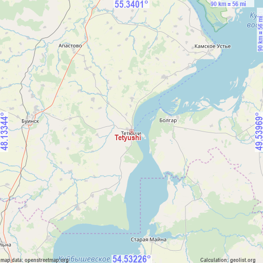
Tetyushi GPS coordinates[2]
54° 56' 17.556" North, 48° 50' 11.616" East
| Map corner | latitude | longitude |
|---|---|---|
| Upper-left | 55.3401°, | 48.13344° |
| Center: | 54.93821°, | 48.83656° |
| Lower-right: | 54.53226°, | 49.53969° |
| Map W x H: | 89.8×89.8 km | = 55.8×55.8mi |
| max Lat: | 73.50819° ⇑47.4% North |
| Tetyushi: | 54.93821° |
| min Lat: | ⇓52.6% South 41.28413° |
| min Long | Tetyushi | max Long |
| -179.12198° | 48.83656° | 179.35046° |
| W 60.5%⇐ | ⇒39.5% E |
Elevation
Elevation of Tetyushi is 142 m = 466 ft, and this is 60.6 m = 199 ft below average elevation for this country.
| Max E: |
2518 m = 8261 ft | 51.1% |
| Avg. | 202.6 m = 665 ft | |
| Tetyushi | 142 m = 466 ft | |
Min E: |
-28 m = -92 ft | 48.9% |
See also: Russia elevation on elevation.city.
Geographical zone
Tetyushi is located in North temperate zone (between Tropic of Cancer and the Arctic Circle). Distance of this North polar circle is 1292.6 km =803.2 mi to North.| Distance of | km | miles | from Tetyushi |
|---|---|---|---|
| North Pole | 3898.5 | 2422.4 | to North |
| Arctic Circle | 1292.6 | 803.2 | to North |
| Tropic Cancer | 3502.6 | 2176.4 | to South |
| Equator | 6108.6 | 3795.7 | to South |


Nearby cities:
15 places around Tetyushi: (largest is in red/bold)
• Apastovo
36 km =22.4 mi,  324°
324°
• Batyrevo
79.5 km =49.4 mi,  280°
280°
• Bazarnyye Mataki
70.4 km =43.7 mi,  94°
94°
• Bolgar
14.8 km =9.2 mi,  84°
84°
• Buinsk
35 km =21.7 mi, 276°
• Cherdakly
64.4 km =40 mi,  179°
179°
• Isheyevka
67.5 km =41.9 mi,  212°
212°
• Kuybyshevskiy Zaton
32.5 km =20.2 mi,  40°
40°
• Laishevo
68.9 km =42.8 mi, 41°
• Mirnyy
64 km =39.8 mi,  186°
186°
• Staraya Mayna
37.6 km =23.4 mi,  170°
170°
• Stolbishchi
82.4 km =51.2 mi,  16°
16°
• Tsil’na
58.7 km =36.5 mi,  229°
229°
• Ulyanovsk
73.7 km =45.8 mi,  203°
203°
• Undory
46.4 km =28.8 mi,  217°
217°
Sources, notices
• [Note1] Compared only with cities in Russia existing in our database
• [Src1] Map data: © OpenStreetMap contributors (CC-BY-SA)
• [Src2] Other city data from geonames.org with taken over terms of usage.
• [Src3] Geographical zone / Annual Mean Temperature by Robert A. Rohde @ Wikipedia
