Sovetskoye geodata
Sovetskoye (Altai Krai) is a populated place; located in Russia in Asia/Barnaul (GMT+7) time zone. With population of 5,441 people, there are 2459 cities with bigger population in this country. Compared to other cities in Russia, 67.4% of cities are located further ↑North; 82.6% of cities are located further ←West and 72.6% of cities have lower elevation than Sovetskoye. Note1


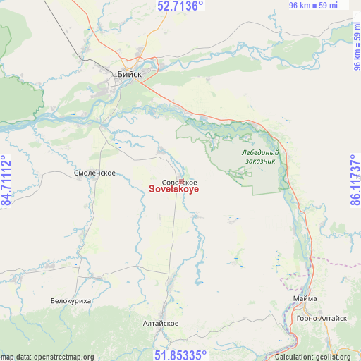
Sovetskoye GPS coordinates[2]
52° 17' 8.016" North, 85° 24' 51.264" East
| Map corner | latitude | longitude |
|---|---|---|
| Upper-left | 52.7136°, | 84.71112° |
| Center: | 52.28556°, | 85.41424° |
| Lower-right: | 51.85335°, | 86.11737° |
| Map W x H: | 95.7×95.6 km | = 59.5×59.4mi |
| max Lat: | 73.50819° ⇑67.4% North |
| Sovetskoye: | 52.28556° |
| min Lat: | ⇓32.6% South 41.28413° |
| min Long | Sovetskoye | max Long |
| -179.12198° | 85.41424° | 179.35046° |
| W 82.6%⇐ | ⇒17.4% E |
Elevation
Elevation of Sovetskoye is 207 m = 679 ft, and this is 4.4 m = 14 ft above average elevation for this country.
| Max E: |
2518 m = 8261 ft | 27.4% |
| Sovetskoye | 207 m 679 ft | |
| Avg. | 202.6 m = 665 ft | |
Min E: |
-28 m = -92 ft | 72.6% |
See also: Russia elevation on elevation.city.
Geographical zone
Sovetskoye is located in North temperate zone (between Tropic of Cancer and the Arctic Circle). Distance of this North polar circle is 1587.6 km =986.5 mi to North.| Distance of | km | miles | from Sovetskoye |
|---|---|---|---|
| North Pole | 4193.5 | 2605.7 | to North |
| Arctic Circle | 1587.6 | 986.5 | to North |
| Tropic Cancer | 3207.7 | 1993.2 | to South |
| Equator | 5813.6 | 3612.4 | to South |


Nearby cities:
15 places around Sovetskoye: (largest is in red/bold)
• Berëzovka
29 km =18 mi,  75°
75°
• Biysk
31.2 km =19.4 mi,  333°
333°
• Bystryanka
28.2 km =17.5 mi,  89°
89°
• Kokshi
13.6 km =8.5 mi,  37°
37°
• Krasnyy Yar
9.5 km =5.9 mi, 327°
• Lesnoye
23.1 km =14.4 mi, 332°
• Malougrenevo
30.6 km =19 mi,  350°
350°
• Setovka
10.3 km =6.4 mi,  157°
157°
• Shul’gin Log
32.7 km =20.3 mi,  113°
113°
• Smolenskoye
22.9 km =14.2 mi,  275°
275°
• Srostki
24.5 km =15.2 mi,  52°
52°
• Starobelokurikha
34.2 km =21.3 mi,  220°
220°
• Verkh-Katunskoye
18.3 km =11.4 mi,  3°
3°
• Verkh-Obskiy
30.7 km =19.1 mi,  298°
298°
• Половинка
14.1 km =8.8 mi,  137°
137°
Sources, notices
• [Note1] Compared only with cities in Russia existing in our database
• [Src1] Map data: © OpenStreetMap contributors (CC-BY-SA)
• [Src2] Other city data from geonames.org with taken over terms of usage.
• [Src3] Geographical zone / Annual Mean Temperature by Robert A. Rohde @ Wikipedia
