Starobelokurikha geodata
Starobelokurikha (Altai Krai) is a populated place; located in Russia in Asia/Barnaul (GMT+7) time zone. With population of 1,480 people, there are 4396 cities with bigger population in this country. Compared to other cities in Russia, 68.9% of cities are located further ↑North; 82.3% of cities are located further ←West and 74.3% of cities have lower elevation than Starobelokurikha. Note1


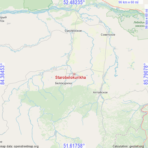
Starobelokurikha GPS coordinates[2]
52° 3' 7.416" North, 85° 5' 15.54" East
| Map corner | latitude | longitude |
|---|---|---|
| Upper-left | 52.48235°, | 84.38453° |
| Center: | 52.05206°, | 85.08765° |
| Lower-right: | 51.61758°, | 85.79078° |
| Map W x H: | 96.2×96.2 km | = 59.8×59.8mi |
| max Lat: | 73.50819° ⇑68.9% North |
| Starobelokurikha: | 52.05206° |
| min Lat: | ⇓31.1% South 41.28413° |
| min Long | Starobelokurikh | max Long |
| -179.12198° | 85.08765° | 179.35046° |
| W 82.3%⇐ | ⇒17.7% E |
Elevation
Elevation of Starobelokurikha is 213 m = 699 ft, and this is 10.4 m = 34 ft above average elevation for this country.
| Max E: |
2518 m = 8261 ft | 25.7% |
| Starobelokurikha | 213 m 699 ft | |
| Avg. | 202.6 m = 665 ft | |
Min E: |
-28 m = -92 ft | 74.3% |
See also: Russia elevation on elevation.city.
Geographical zone
Starobelokurikha is located in North temperate zone (between Tropic of Cancer and the Arctic Circle). Distance of this North polar circle is 1613.5 km =1002.6 mi to North.| Distance of | km | miles | from Starobelokurikha |
|---|---|---|---|
| North Pole | 4219.4 | 2621.8 | to North |
| Arctic Circle | 1613.5 | 1002.6 | to North |
| Tropic Cancer | 3181.7 | 1977 | to South |
| Equator | 5787.6 | 3596.2 | to South |


Nearby cities:
15 places around Starobelokurikha: (largest is in red/bold)
• Altayskoye
20 km =12.4 mi,  123°
123°
• Belokurikha
9.2 km =5.7 mi,  227°
227°
• Kokshi
47.8 km =29.7 mi,  39°
39°
• Krasnyy Yar
38 km =23.6 mi,  26°
26°
• Lesnoye
47.8 km =29.7 mi,  13°
13°
• Novopokrovka
48.4 km =30.1 mi,  293°
293°
• Novotyryshkino
12.7 km =7.9 mi, 285°
• Sarasa
26.8 km =16.7 mi,  136°
136°
• Setovka
31 km =19.3 mi,  57°
57°
• Smolenskoye
28.1 km =17.5 mi,  358°
358°
• Sovetskoye
34.2 km =21.3 mi, 40°
• Sychëvka
21.1 km =13.1 mi,  269°
269°
• Verkh-Katunskoye
50.1 km =31.1 mi, 27°
• Verkh-Obskiy
40.9 km =25.4 mi,  353°
353°
• Половинка
35.4 km =22 mi, 63°
Sources, notices
• [Note1] Compared only with cities in Russia existing in our database
• [Src1] Map data: © OpenStreetMap contributors (CC-BY-SA)
• [Src2] Other city data from geonames.org with taken over terms of usage.
• [Src3] Geographical zone / Annual Mean Temperature by Robert A. Rohde @ Wikipedia
