Safakulevo geodata
Safakulevo (Kurgan Oblast) is a populated place; located in Russia in Asia/Yekaterinburg (GMT+5) time zone. With population of 4,189 people, there are 3007 cities with bigger population in this country. Compared to other cities in Russia, 53.1% of cities are located further ↓South; 74.7% of cities are located further ←West and 63.8% of cities have lower elevation than Safakulevo. Note1


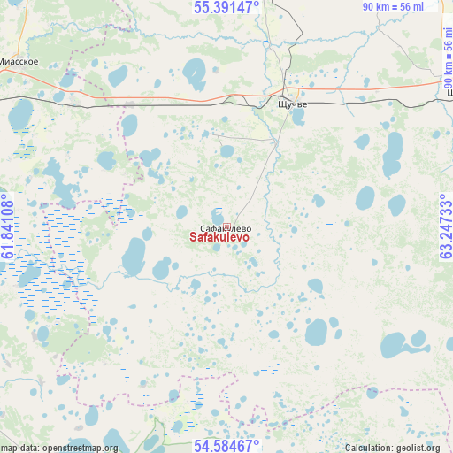
Safakulevo GPS coordinates[2]
54° 59' 24.36" North, 62° 32' 39.12" East
| Map corner | latitude | longitude |
|---|---|---|
| Upper-left | 55.39147°, | 61.84108° |
| Center: | 54.9901°, | 62.5442° |
| Lower-right: | 54.58467°, | 63.24733° |
| Map W x H: | 89.7×89.7 km | = 55.7×55.7mi |
| max Lat: | 73.50819° ⇑46.9% North |
| Safakulevo: | 54.9901° |
| min Lat: | ⇓53.1% South 41.28413° |
| min Long | Safakulevo | max Long |
| -179.12198° | 62.5442° | 179.35046° |
| W 74.7%⇐ | ⇒25.3% E |
Elevation
Elevation of Safakulevo is 179 m = 587 ft, and this is 23.6 m = 77 ft below average elevation for this country.
| Max E: |
2518 m = 8261 ft | 36.2% |
| Avg. | 202.6 m = 665 ft | |
| Safakulevo | 179 m = 587 ft | |
Min E: |
-28 m = -92 ft | 63.8% |
See also: Russia elevation on elevation.city.
Geographical zone
Safakulevo is located in North temperate zone (between Tropic of Cancer and the Arctic Circle). Distance of this North polar circle is 1286.8 km =799.6 mi to North.| Distance of | km | miles | from Safakulevo |
|---|---|---|---|
| North Pole | 3892.7 | 2418.8 | to North |
| Arctic Circle | 1286.8 | 799.6 | to North |
| Tropic Cancer | 3508.4 | 2180 | to South |
| Equator | 6114.3 | 3799.2 | to South |


Nearby cities:
15 places around Safakulevo: (largest is in red/bold)
• Bazhovo
60.4 km =37.5 mi,  277°
277°
• Brodokalmak
71.3 km =44.3 mi,  335°
335°
• Chelyabinsk
73.3 km =45.5 mi, 284°
• Gornyak
57.2 km =35.5 mi,  286°
286°
• Kanashevo
39.6 km =24.6 mi,  309°
309°
• Kopeysk
60 km =37.3 mi, 283°
• Miasskoye
52.5 km =32.6 mi, 307°
• Potanino
62.3 km =38.7 mi, 289°
• Roza
69.8 km =43.4 mi,  263°
263°
• Selezyan
46.9 km =29.1 mi, 258°
• Shumikha
54.6 km =33.9 mi,  61°
61°
• Starokamyshinsk
61.2 km =38 mi, 275°
• Vakhrushevo
59.1 km =36.7 mi,  297°
297°
• Yetkul’
63.9 km =39.7 mi,  253°
253°
• Zheleznodorozhnyy
64.6 km =40.1 mi, 281°
Sources, notices
• [Note1] Compared only with cities in Russia existing in our database
• [Src1] Map data: © OpenStreetMap contributors (CC-BY-SA)
• [Src2] Other city data from geonames.org with taken over terms of usage.
• [Src3] Geographical zone / Annual Mean Temperature by Robert A. Rohde @ Wikipedia
