Muslyumovo geodata
Muslyumovo (Chelyabinsk) is a populated place; located in Russia in Asia/Yekaterinburg (GMT+5) time zone. With population of 4,500 people, there are 2866 cities with bigger population in this country. Compared to other cities in Russia, 60% of cities are located further ↓South; 74% of cities are located further ←West and 62.4% of cities have lower elevation than Muslyumovo. Note1


Muslyumovo GPS coordinates[2]
55° 36' 47.88" North, 61° 37' 33.6" East
| Map corner | latitude | longitude |
|---|---|---|
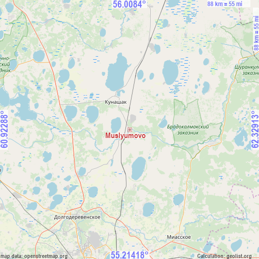
| Upper-left | 56.0084°, | 60.92288° |
| Center: | 55.6133°, | 61.626° |
| Lower-right: | 55.21418°, | 62.32913° |
| Map W x H: | 88.3×88.3 km | = 54.9×54.9mi |
| max Lat: | 73.50819° ⇑40% North |
| Muslyumovo: | 55.6133° |
| min Lat: | ⇓60% South 41.28413° |
| min Long | Muslyumovo | max Long |
| -179.12198° | 61.626° | 179.35046° |
| W 74%⇐ | ⇒26% E |
Elevation
Elevation of Muslyumovo is 175 m = 574 ft, and this is 27.6 m = 91 ft below average elevation for this country.
| Max E: |
2518 m = 8261 ft | 37.6% |
| Avg. | 202.6 m = 665 ft | |
| Muslyumovo | 175 m = 574 ft | |
Min E: |
-28 m = -92 ft | 62.4% |
See also: Russia elevation on elevation.city.
Geographical zone
Muslyumovo is located in North temperate zone (between Tropic of Cancer and the Arctic Circle). Distance of this North polar circle is 1217.6 km =756.6 mi to North.| Distance of | km | miles | from Muslyumovo |
|---|---|---|---|
| North Pole | 3823.4 | 2375.7 | to North |
| Arctic Circle | 1217.6 | 756.6 | to North |
| Tropic Cancer | 3577.7 | 2223.1 | to South |
| Equator | 6183.6 | 3842.3 | to South |


Nearby cities:
15 places around Muslyumovo: (largest is in red/bold)
• Argayash
49.1 km =30.5 mi,  253°
253°
• Brodokalmak
29 km =18 mi,  98°
98°
• Chelyabinsk
52.6 km =32.7 mi,  193°
193°
• Dolgoderevenskoye
34.8 km =21.6 mi,  210°
210°
• Gornyak
53.4 km =33.2 mi,  176°
176°
• Kanashevo
52 km =32.3 mi,  147°
147°
• Kopeysk
55.2 km =34.3 mi, 179°
• Kunashak
11.1 km =6.9 mi,  334°
334°
• Miasskoye
40.8 km =25.4 mi,  155°
155°
• Novogornyy
52.4 km =32.6 mi,  272°
272°
• Potanino
48.3 km =30 mi, 180°
• Roshchino
40.7 km =25.3 mi, 214°
• Ust’-Bagaryak
59.4 km =36.9 mi,  13°
13°
• Vakhrushevo
42.8 km =26.6 mi,  172°
172°
• Zheleznodorozhnyy
57.1 km =35.5 mi, 184°
Sources, notices
• [Note1] Compared only with cities in Russia existing in our database
• [Src1] Map data: © OpenStreetMap contributors (CC-BY-SA)
• [Src2] Other city data from geonames.org with taken over terms of usage.
• [Src3] Geographical zone / Annual Mean Temperature by Robert A. Rohde @ Wikipedia
