Argayash geodata
Argayash (Chelyabinsk) is a populated place; located in Russia in Asia/Yekaterinburg (GMT+5) time zone. With population of 10,096 people, there are 1497 cities with bigger population in this country. Compared to other cities in Russia, 57.9% of cities are located further ↓South; 73.1% of cities are located further ←West and 80.9% of cities have lower elevation than Argayash. Note1


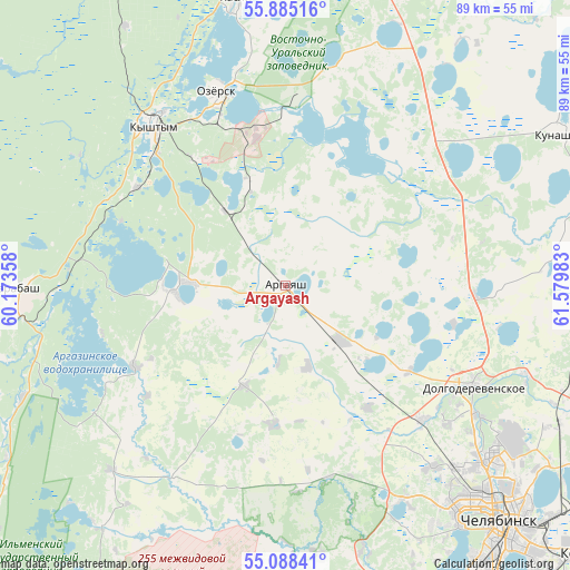
Argayash GPS coordinates[2]
55° 29' 19.68" North, 60° 52' 36.12" East
| Map corner | latitude | longitude |
|---|---|---|
| Upper-left | 55.88516°, | 60.17358° |
| Center: | 55.4888°, | 60.8767° |
| Lower-right: | 55.08841°, | 61.57983° |
| Map W x H: | 88.6×88.6 km | = 55.1×55.1mi |
| max Lat: | 73.50819° ⇑42.1% North |
| Argayash: | 55.4888° |
| min Lat: | ⇓57.9% South 41.28413° |
| min Long | Argayash | max Long |
| -179.12198° | 60.8767° | 179.35046° |
| W 73.1%⇐ | ⇒26.9% E |
Elevation
Elevation of Argayash is 256 m = 840 ft, and this is 53.4 m = 175 ft above average elevation for this country.
| Max E: |
2518 m = 8261 ft | 19.1% |
| Argayash | 256 m 840 ft | |
| Avg. | 202.6 m = 665 ft | |
Min E: |
-28 m = -92 ft | 80.9% |
See also: Russia elevation on elevation.city.
Geographical zone
Argayash is located in North temperate zone (between Tropic of Cancer and the Arctic Circle). Distance of this North polar circle is 1231.4 km =765.2 mi to North.| Distance of | km | miles | from Argayash |
|---|---|---|---|
| North Pole | 3837.3 | 2384.4 | to North |
| Arctic Circle | 1231.4 | 765.2 | to North |
| Tropic Cancer | 3563.9 | 2214.5 | to South |
| Equator | 6169.8 | 3833.7 | to South |


Nearby cities:
15 places around Argayash: (largest is in red/bold)
• Chelyabinsk
51.1 km =31.8 mi,  136°
136°
• Dolgoderevenskoye
33.6 km =20.9 mi,  118°
118°
• Karabash
41.7 km =25.9 mi,  268°
268°
• Kasli
45.3 km =28.1 mi,  350°
350°
• Kunashak
48.5 km =30.1 mi,  60°
60°
• Kyshtym
32.3 km =20.1 mi,  320°
320°
• Muslyumovo
49.1 km =30.5 mi,  73°
73°
• Novogornyy
16.6 km =10.3 mi,  341°
341°
• Ozersk
31.6 km =19.6 mi, 339°
• Poletayevo
52.8 km =32.8 mi,  163°
163°
• Roshchino
31.5 km =19.6 mi,  129°
129°
• Sargazy
57.2 km =35.5 mi, 155°
• Tayginka
27.7 km =17.2 mi,  303°
303°
• Uvil’dy
19.3 km =12 mi,  283°
283°
• Vishnëvogorsk
57.5 km =35.7 mi, 346°
Sources, notices
• [Note1] Compared only with cities in Russia existing in our database
• [Src1] Map data: © OpenStreetMap contributors (CC-BY-SA)
• [Src2] Other city data from geonames.org with taken over terms of usage.
• [Src3] Geographical zone / Annual Mean Temperature by Robert A. Rohde @ Wikipedia
