Motygino geodata
Motygino (Krasnoyarskiy) is a populated place; located in Russia in Asia/Krasnoyarsk (GMT+7) time zone. With population of 6,625 people, there are 2093 cities with bigger population in this country. Compared to other cities in Russia, 83.4% of cities are located further ↓South; 87.1% of cities are located further ←West and 60.6% of cities have higher elevation than Motygino. Note1


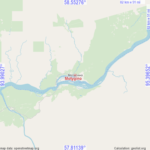
Motygino GPS coordinates[2]
58° 11' 2.436" North, 94° 41' 36.204" East
| Map corner | latitude | longitude |
|---|---|---|
| Upper-left | 58.55276°, | 93.99027° |
| Center: | 58.18401°, | 94.69339° |
| Lower-right: | 57.81139°, | 95.39652° |
| Map W x H: | 82.4×82.4 km | = 51.2×51.2mi |
| max Lat: | 73.50819° ⇑16.6% North |
| Motygino: | 58.18401° |
| min Lat: | ⇓83.4% South 41.28413° |
| min Long | Motygino | max Long |
| -179.12198° | 94.69339° | 179.35046° |
| W 87.1%⇐ | ⇒12.9% E |
Elevation
Elevation of Motygino is 123 m = 404 ft, and this is 79.6 m = 261 ft below average elevation for this country.
| Max E: |
2518 m = 8261 ft | 60.6% |
| Avg. | 202.6 m = 665 ft | |
| Motygino | 123 m = 404 ft | |
Min E: |
-28 m = -92 ft | 39.4% |
See also: Russia elevation on elevation.city.
Geographical zone
Motygino is located in North temperate zone (between Tropic of Cancer and the Arctic Circle). Distance of this North polar circle is 931.7 km =578.9 mi to North.| Distance of | km | miles | from Motygino |
|---|---|---|---|
| North Pole | 3537.6 | 2198.2 | to North |
| Arctic Circle | 931.7 | 578.9 | to North |
| Tropic Cancer | 3863.5 | 2400.7 | to South |
| Equator | 6469.5 | 4020 | to South |


Nearby cities:
15 places around Motygino: (largest is in red/bold)
• Aban
186.4 km =115.8 mi,  153°
153°
• Boguchany
162.8 km =101.2 mi,  82°
82°
• Chunoyar
176.2 km =109.5 mi,  117°
117°
• Dzerzhinskoye
153.4 km =95.3 mi,  167°
167°
• Kazachinskoye
99.2 km =61.6 mi,  237°
237°
• Lesosibirsk
129.6 km =80.5 mi,  272°
272°
• Manzya
97.7 km =60.7 mi,  69°
69°
• Pirovskoye
156.2 km =97.1 mi,  246°
246°
• Predivinsk
145.3 km =90.3 mi,  210°
210°
• Razdolinsk
26.4 km =16.4 mi,  356°
356°
• Strelka
98.2 km =61 mi,  262°
262°
• Sukhobuzimskoye
205.7 km =127.8 mi,  204°
204°
• Taseyevo
108.4 km =67.4 mi, 173°
• Yeniseysk
149.7 km =93 mi,  281°
281°
• Yuzhno-Yeniseyskiy
66.9 km =41.6 mi, 356°
Sources, notices
• [Note1] Compared only with cities in Russia existing in our database
• [Src1] Map data: © OpenStreetMap contributors (CC-BY-SA)
• [Src2] Other city data from geonames.org with taken over terms of usage.
• [Src3] Geographical zone / Annual Mean Temperature by Robert A. Rohde @ Wikipedia
