Dzerzhinskoye geodata
Dzerzhinskoye (Krasnoyarskiy) is a populated place; located in Russia in Asia/Krasnoyarsk (GMT+7) time zone. With population of 7,775 people, there are 1859 cities with bigger population in this country. Compared to other cities in Russia, 75.7% of cities are located further ↓South; 87.3% of cities are located further ←West and 64.6% of cities have lower elevation than Dzerzhinskoye. Note1


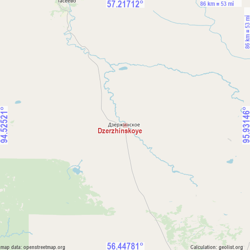
Dzerzhinskoye GPS coordinates[2]
56° 50' 3.984" North, 95° 13' 41.988" East
| Map corner | latitude | longitude |
|---|---|---|
| Upper-left | 57.21712°, | 94.52521° |
| Center: | 56.83444°, | 95.22833° |
| Lower-right: | 56.44781°, | 95.93146° |
| Map W x H: | 85.5×85.5 km | = 53.1×53.1mi |
| max Lat: | 73.50819° ⇑24.3% North |
| Dzerzhinskoye: | 56.83444° |
| min Lat: | ⇓75.7% South 41.28413° |
| min Long | Dzerzhinskoye | max Long |
| -179.12198° | 95.22833° | 179.35046° |
| W 87.3%⇐ | ⇒12.7% E |
Elevation
Elevation of Dzerzhinskoye is 181 m = 594 ft, and this is 21.6 m = 71 ft below average elevation for this country.
| Max E: |
2518 m = 8261 ft | 35.4% |
| Avg. | 202.6 m = 665 ft | |
| Dzerzhinskoye | 181 m = 594 ft | |
Min E: |
-28 m = -92 ft | 64.6% |
See also: Russia elevation on elevation.city.
Geographical zone
Dzerzhinskoye is located in North temperate zone (between Tropic of Cancer and the Arctic Circle). Distance of this North polar circle is 1081.8 km =672.2 mi to North.| Distance of | km | miles | from Dzerzhinskoye |
|---|---|---|---|
| North Pole | 3687.7 | 2291.4 | to North |
| Arctic Circle | 1081.8 | 672.2 | to North |
| Tropic Cancer | 3713.5 | 2307.5 | to South |
| Equator | 6319.4 | 3926.7 | to South |


Nearby cities:
15 places around Dzerzhinskoye: (largest is in red/bold)
• Aban
53.9 km =33.5 mi,  108°
108°
• Borodino
105.1 km =65.3 mi,  190°
190°
• Filimonovo
71.9 km =44.7 mi,  168°
168°
• Ilanskiy
84.3 km =52.4 mi,  142°
142°
• Irsha
104.3 km =64.8 mi, 194°
• Kansk
76.5 km =47.5 mi,  156°
156°
• Nizhniy Ingash
106.9 km =66.4 mi,  131°
131°
• Predivinsk
111.5 km =69.3 mi,  283°
283°
• Sukhobuzimskoye
125.1 km =77.7 mi,  252°
252°
• Taseyevo
46.9 km =29.1 mi,  334°
334°
• Tinskoy
128.5 km =79.8 mi, 126°
• Ural
107.4 km =66.7 mi,  195°
195°
• Uyar
126.6 km =78.7 mi,  206°
206°
• Zelenogorsk
89.1 km =55.4 mi, 205°
• Zheleznogorsk
122.6 km =76.2 mi,  238°
238°
Sources, notices
• [Note1] Compared only with cities in Russia existing in our database
• [Src1] Map data: © OpenStreetMap contributors (CC-BY-SA)
• [Src2] Other city data from geonames.org with taken over terms of usage.
• [Src3] Geographical zone / Annual Mean Temperature by Robert A. Rohde @ Wikipedia
