Kiselëvsk geodata
Kiselëvsk (Kemerovo Oblast) is a populated place; located in Russia in Asia/Novokuznetsk (GMT+7) time zone. With population of 104,000 people, there are 195 cities with bigger population in this country. Compared to other cities in Russia, 55.3% of cities are located further ↑North; 84.4% of cities are located further ←West and 85% of cities have lower elevation than Kiselëvsk. Note1


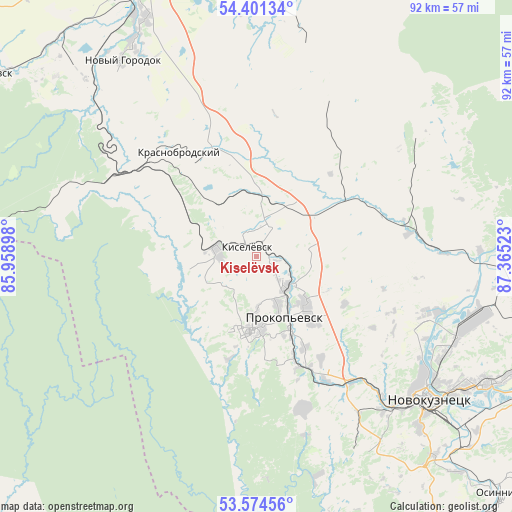
Kiselëvsk GPS coordinates[2]
53° 59' 24" North, 86° 39' 43.56" East
| Map corner | latitude | longitude |
|---|---|---|
| Upper-left | 54.40134°, | 85.95898° |
| Center: | 53.99°, | 86.6621° |
| Lower-right: | 53.57456°, | 87.36523° |
| Map W x H: | 91.9×91.9 km | = 57.1×57.1mi |
| max Lat: | 73.50819° ⇑55.3% North |
| Kiselëvsk: | 53.99° |
| min Lat: | ⇓44.7% South 41.28413° |
| min Long | Kiselëvsk | max Long |
| -179.12198° | 86.6621° | 179.35046° |
| W 84.4%⇐ | ⇒15.6% E |
Elevation
Elevation of Kiselëvsk is 320 m = 1050 ft, and this is 117.4 m = 385 ft above average elevation for this country.
| Max E: |
2518 m = 8261 ft | 15% |
| Kiselëvsk | 320 m 1050 ft | |
| Avg. | 202.6 m = 665 ft | |
Min E: |
-28 m = -92 ft | 85% |
See also: Kiselëvsk elevation on elevation.city.
Geographical zone
Kiselëvsk is located in North temperate zone (between Tropic of Cancer and the Arctic Circle). Distance of this North polar circle is 1398 km =868.7 mi to North.| Distance of | km | miles | from Kiselëvsk |
|---|---|---|---|
| North Pole | 4003.9 | 2487.9 | to North |
| Arctic Circle | 1398 | 868.7 | to North |
| Tropic Cancer | 3397.2 | 2110.9 | to South |
| Equator | 6003.1 | 3730.2 | to South |


Nearby cities:
15 places around Kiselëvsk: (largest is in red/bold)
• Abagur
48.3 km =30 mi,  126°
126°
• Artyshta
28.3 km =17.6 mi,  301°
301°
• Bachatskiy
48.4 km =30.1 mi,  314°
314°
• Belovo
53 km =32.9 mi,  333°
333°
• Chistogorskiy
47.2 km =29.3 mi,  90°
90°
• Gur’yevsk
57.6 km =35.8 mi, 304°
• Inskoy
51 km =31.7 mi,  343°
343°
• Karagayla
21.5 km =13.4 mi, 340°
• Krasnobrodskiy
23.3 km =14.5 mi,  323°
323°
• Listvyagi
39.6 km =24.6 mi,  151°
151°
• Novokuznetsk
39.2 km =24.4 mi, 131°
• Prokop’yevsk
10.1 km =6.3 mi,  158°
158°
• Sosnovka
48.2 km =30 mi,  138°
138°
• Starobachaty
40.8 km =25.4 mi, 313°
• Trudarmeyskiy
22.8 km =14.2 mi, 313°
Sources, notices
• [Note1] Compared only with cities in Russia existing in our database
• [Src1] Map data: © OpenStreetMap contributors (CC-BY-SA)
• [Src2] Other city data from geonames.org with taken over terms of usage.
• [Src3] Geographical zone / Annual Mean Temperature by Robert A. Rohde @ Wikipedia
