Dvurechensk geodata
Dvurechensk (Sverdlovsk) is a populated place; located in Russia in Asia/Yekaterinburg (GMT+5) time zone. With population of 5,121 people, there are 2597 cities with bigger population in this country. Compared to other cities in Russia, 73.5% of cities are located further ↓South; 73.4% of cities are located further ←West and 70.2% of cities have lower elevation than Dvurechensk. Note1


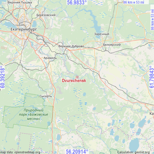
Dvurechensk GPS coordinates[2]
56° 35' 53.52" North, 61° 5' 43.08" East
| Map corner | latitude | longitude |
|---|---|---|
| Upper-left | 56.9833°, | 60.39218° |
| Center: | 56.5982°, | 61.0953° |
| Lower-right: | 56.20914°, | 61.79843° |
| Map W x H: | 86.1×86.1 km | = 53.5×53.5mi |
| max Lat: | 73.50819° ⇑26.5% North |
| Dvurechensk: | 56.5982° |
| min Lat: | ⇓73.5% South 41.28413° |
| min Long | Dvurechensk | max Long |
| -179.12198° | 61.0953° | 179.35046° |
| W 73.4%⇐ | ⇒26.6% E |
Elevation
Elevation of Dvurechensk is 198 m = 650 ft, and this is 4.6 m = 15 ft below average elevation for this country.
| Max E: |
2518 m = 8261 ft | 29.8% |
| Avg. | 202.6 m = 665 ft | |
| Dvurechensk | 198 m = 650 ft | |
Min E: |
-28 m = -92 ft | 70.2% |
See also: Russia elevation on elevation.city.
Geographical zone
Dvurechensk is located in North temperate zone (between Tropic of Cancer and the Arctic Circle). Distance of this North polar circle is 1108 km =688.5 mi to North.| Distance of | km | miles | from Dvurechensk |
|---|---|---|---|
| North Pole | 3713.9 | 2307.7 | to North |
| Arctic Circle | 1108 | 688.5 | to North |
| Tropic Cancer | 3687.2 | 2291.1 | to South |
| Equator | 6293.1 | 3910.3 | to South |


Nearby cities:
15 places around Dvurechensk: (largest is in red/bold)
• Aramil
19.3 km =12 mi,  305°
305°
• Beloyarskiy
26.4 km =16.4 mi,  47°
47°
• Bobrovskiy
10.9 km =6.8 mi,  319°
319°
• Gornyy Shchit
36.6 km =22.7 mi,  285°
285°
• Istok
28.8 km =17.9 mi, 317°
• Pokrovskoye
34.6 km =21.5 mi,  114°
114°
• Sarapulka
30.1 km =18.7 mi,  355°
355°
• Shabrovskiy
31.8 km =19.8 mi,  277°
277°
• Shchelkun
34 km =21.1 mi,  195°
195°
• Sovkhoznyy
20.7 km =12.9 mi,  101°
101°
• Sovkhoznyy
38.1 km =23.7 mi,  298°
298°
• Sysert’
20 km =12.4 mi,  237°
237°
• Verkhneye Dubrovo
17.4 km =10.8 mi,  350°
350°
• Verkhnyaya Sysert’
27.3 km =17 mi,  229°
229°
• Zarechnyy
27.5 km =17.1 mi,  30°
30°
Sources, notices
• [Note1] Compared only with cities in Russia existing in our database
• [Src1] Map data: © OpenStreetMap contributors (CC-BY-SA)
• [Src2] Other city data from geonames.org with taken over terms of usage.
• [Src3] Geographical zone / Annual Mean Temperature by Robert A. Rohde @ Wikipedia
