Sovkhoznyy geodata
Sovkhoznyy (Sverdlovsk) is a populated place; located in Russia in Asia/Yekaterinburg (GMT+5) time zone. With population of 3,546 people, there are 3376 cities with bigger population in this country. Compared to other cities in Russia, 73.3% of cities are located further ↓South; 73.8% of cities are located further ←West and 77.1% of cities have lower elevation than Sovkhoznyy. Note1


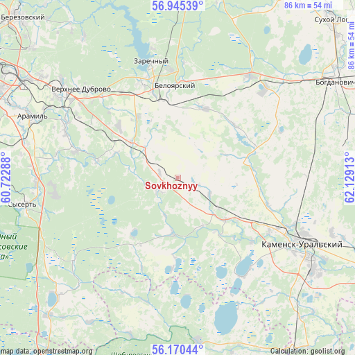
Sovkhoznyy GPS coordinates[2]
56° 33' 35.64" North, 61° 25' 33.6" East
| Map corner | latitude | longitude |
|---|---|---|
| Upper-left | 56.94539°, | 60.72288° |
| Center: | 56.5599°, | 61.426° |
| Lower-right: | 56.17044°, | 62.12913° |
| Map W x H: | 86.2×86.2 km | = 53.6×53.6mi |
| max Lat: | 73.50819° ⇑26.7% North |
| Sovkhoznyy: | 56.5599° |
| min Lat: | ⇓73.3% South 41.28413° |
| min Long | Sovkhoznyy | max Long |
| -179.12198° | 61.426° | 179.35046° |
| W 73.8%⇐ | ⇒26.2% E |
Elevation
Elevation of Sovkhoznyy is 227 m = 745 ft, and this is 24.4 m = 80 ft above average elevation for this country.
| Max E: |
2518 m = 8261 ft | 22.9% |
| Sovkhoznyy | 227 m 745 ft | |
| Avg. | 202.6 m = 665 ft | |
Min E: |
-28 m = -92 ft | 77.1% |
See also: Russia elevation on elevation.city.
Geographical zone
Sovkhoznyy is located in North temperate zone (between Tropic of Cancer and the Arctic Circle). Distance of this North polar circle is 1112.3 km =691.2 mi to North.| Distance of | km | miles | from Sovkhoznyy |
|---|---|---|---|
| North Pole | 3718.2 | 2310.4 | to North |
| Arctic Circle | 1112.3 | 691.2 | to North |
| Tropic Cancer | 3683 | 2288.5 | to South |
| Equator | 6288.9 | 3907.7 | to South |


Nearby cities:
15 places around Sovkhoznyy: (largest is in red/bold)
• Aramil
39.2 km =24.4 mi,  293°
293°
• Baraba
29.7 km =18.5 mi,  44°
44°
• Beloyarskiy
22.1 km =13.7 mi,  358°
358°
• Bobrovskiy
30 km =18.6 mi, 294°
• Dvurechensk
20.7 km =12.9 mi,  281°
281°
• Gryaznovskoye
30.1 km =18.7 mi,  34°
34°
• Kamensk-Ural’skiy
34.9 km =21.7 mi,  116°
116°
• Martyush
33.2 km =20.6 mi, 122°
• Pokrovskoye
15 km =9.3 mi,  131°
131°
• Sarapulka
41 km =25.5 mi,  326°
326°
• Shchelkun
40.9 km =25.4 mi,  225°
225°
• Sysert’
37.8 km =23.5 mi,  260°
260°
• Verkhneye Dubrovo
31.6 km =19.6 mi,  312°
312°
• Verkhnyaya Sysert’
43.2 km =26.8 mi,  252°
252°
• Zarechnyy
28.6 km =17.8 mi,  347°
347°
Sources, notices
• [Note1] Compared only with cities in Russia existing in our database
• [Src1] Map data: © OpenStreetMap contributors (CC-BY-SA)
• [Src2] Other city data from geonames.org with taken over terms of usage.
• [Src3] Geographical zone / Annual Mean Temperature by Robert A. Rohde @ Wikipedia
