Degtyarsk geodata
Degtyarsk (Sverdlovsk) is a populated place; located in Russia in Asia/Yekaterinburg (GMT+5) time zone. With population of 15,294 people, there are 1074 cities with bigger population in this country. Compared to other cities in Russia, 74.5% of cities are located further ↓South; 71.8% of cities are located further ←West and 86.2% of cities have lower elevation than Degtyarsk. Note1


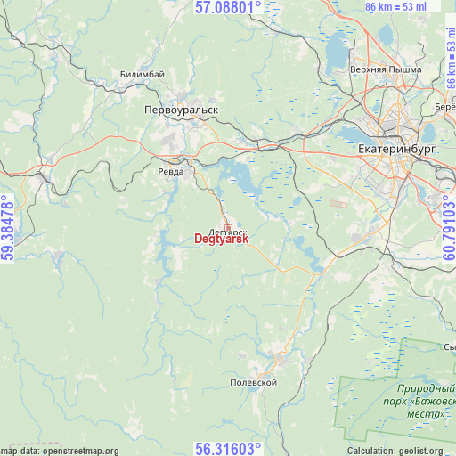
Degtyarsk GPS coordinates[2]
56° 42' 14.4" North, 60° 5' 16.44" East
| Map corner | latitude | longitude |
|---|---|---|
| Upper-left | 57.08801°, | 59.38478° |
| Center: | 56.704°, | 60.0879° |
| Lower-right: | 56.31603°, | 60.79103° |
| Map W x H: | 85.8×85.8 km | = 53.3×53.3mi |
| max Lat: | 73.50819° ⇑25.5% North |
| Degtyarsk: | 56.704° |
| min Lat: | ⇓74.5% South 41.28413° |
| min Long | Degtyarsk | max Long |
| -179.12198° | 60.0879° | 179.35046° |
| W 71.8%⇐ | ⇒28.2% E |
Elevation
Elevation of Degtyarsk is 350 m = 1148 ft, and this is 147.4 m = 484 ft above average elevation for this country.
| Max E: |
2518 m = 8261 ft | 13.8% |
| Degtyarsk | 350 m 1148 ft | |
| Avg. | 202.6 m = 665 ft | |
Min E: |
-28 m = -92 ft | 86.2% |
See also: Russia elevation on elevation.city.
Geographical zone
Degtyarsk is located in North temperate zone (between Tropic of Cancer and the Arctic Circle). Distance of this North polar circle is 1096.3 km =681.2 mi to North.| Distance of | km | miles | from Degtyarsk |
|---|---|---|---|
| North Pole | 3702.2 | 2300.4 | to North |
| Arctic Circle | 1096.3 | 681.2 | to North |
| Tropic Cancer | 3699 | 2298.5 | to South |
| Equator | 6304.9 | 3917.7 | to South |


Nearby cities:
15 places around Degtyarsk: (largest is in red/bold)
• Bilimbay
33.8 km =21 mi,  330°
330°
• Gornyy Shchit
26.4 km =16.4 mi,  93°
93°
• Iset’
35 km =21.7 mi,  29°
29°
• Mariinsk
16.7 km =10.4 mi,  233°
233°
• Pervoural’sk
24 km =14.9 mi,  338°
338°
• Polevskoy
29.7 km =18.5 mi,  168°
168°
• Revda
14.4 km =8.9 mi,  318°
318°
• Severka
22.5 km =14 mi,  35°
35°
• Shabrovskiy
31 km =19.3 mi,  104°
104°
• Shirokaya Rechka
26.4 km =16.4 mi,  66°
66°
• Shuvakish
33.6 km =20.9 mi, 44°
• Sovkhoznyy
28.9 km =18 mi,  76°
76°
• Talitsa
20 km =12.4 mi,  348°
348°
• Verkhniye Sergi
33.1 km =20.6 mi,  258°
258°
• Zyuzel’skiy
24.4 km =15.2 mi, 173°
Sources, notices
• [Note1] Compared only with cities in Russia existing in our database
• [Src1] Map data: © OpenStreetMap contributors (CC-BY-SA)
• [Src2] Other city data from geonames.org with taken over terms of usage.
• [Src3] Geographical zone / Annual Mean Temperature by Robert A. Rohde @ Wikipedia
