Talitsa geodata
Talitsa (Sverdlovsk) is a section of populated place; located in Russia in Asia/Yekaterinburg (GMT+5) time zone. With population of 19,100 people, there are 910 cities with bigger population in this country. Compared to other cities in Russia, 76.2% of cities are located further ↓South; 71.7% of cities are located further ←West and 85.6% of cities have lower elevation than Talitsa. Note1


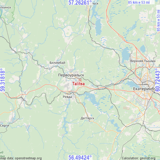
Talitsa GPS coordinates[2]
56° 52' 49.44" North, 60° 1' 16.68" East
| Map corner | latitude | longitude |
|---|---|---|
| Upper-left | 57.26261°, | 59.31818° |
| Center: | 56.8804°, | 60.0213° |
| Lower-right: | 56.49424°, | 60.72443° |
| Map W x H: | 85.4×85.4 km | = 53.1×53.1mi |
| max Lat: | 73.50819° ⇑23.8% North |
| Talitsa: | 56.8804° |
| min Lat: | ⇓76.2% South 41.28413° |
| min Long | Talitsa | max Long |
| -179.12198° | 60.0213° | 179.35046° |
| W 71.7%⇐ | ⇒28.3% E |
Elevation
Elevation of Talitsa is 332 m = 1089 ft, and this is 129.4 m = 425 ft above average elevation for this country.
| Max E: |
2518 m = 8261 ft | 14.4% |
| Talitsa | 332 m 1089 ft | |
| Avg. | 202.6 m = 665 ft | |
Min E: |
-28 m = -92 ft | 85.6% |
See also: Russia elevation on elevation.city.
Geographical zone
Talitsa is located in North temperate zone (between Tropic of Cancer and the Arctic Circle). Distance of this North polar circle is 1076.7 km =669 mi to North.| Distance of | km | miles | from Talitsa |
|---|---|---|---|
| North Pole | 3682.6 | 2288.3 | to North |
| Arctic Circle | 1076.7 | 669 | to North |
| Tropic Cancer | 3718.6 | 2310.6 | to South |
| Equator | 6324.5 | 3929.9 | to South |


Nearby cities:
15 places around Talitsa: (largest is in red/bold)
• Ayat’
21.3 km =13.2 mi,  37°
37°
• Bilimbay
15.9 km =9.9 mi,  308°
308°
• Degtyarsk
20 km =12.4 mi,  168°
168°
• Druzhinino
32.5 km =20.2 mi,  251°
251°
• Iset’
23.9 km =14.9 mi,  62°
62°
• Kalinovo
29 km =18 mi,  15°
15°
• Mariinsk
30.9 km =19.2 mi,  197°
197°
• Novoutkinsk
30.8 km =19.1 mi,  293°
293°
• Pervoural’sk
5.5 km =3.4 mi,  300°
300°
• Revda
10.4 km =6.5 mi,  212°
212°
• Severka
17.1 km =10.6 mi,  94°
94°
• Shirokaya Rechka
29.6 km =18.4 mi,  107°
107°
• Shuvakish
28 km =17.4 mi,  81°
81°
• Sredneuralsk
29.6 km =18.4 mi,  65°
65°
• Tavatuy
32.2 km =20 mi, 20°
Sources, notices
• [Note1] Compared only with cities in Russia existing in our database
• [Src1] Map data: © OpenStreetMap contributors (CC-BY-SA)
• [Src2] Other city data from geonames.org with taken over terms of usage.
• [Src3] Geographical zone / Annual Mean Temperature by Robert A. Rohde @ Wikipedia
