Solnechnyy geodata
Solnechnyy (Krasnoyarskiy) is a section of populated place; located in Russia in Asia/Krasnoyarsk (GMT+7) time zone. With population of 10,641 people, there are 1418 cities with bigger population in this country. Compared to other cities in Russia, 68.1% of cities are located further ↓South; 86.6% of cities are located further ←West and 84.7% of cities have lower elevation than Solnechnyy. Note1


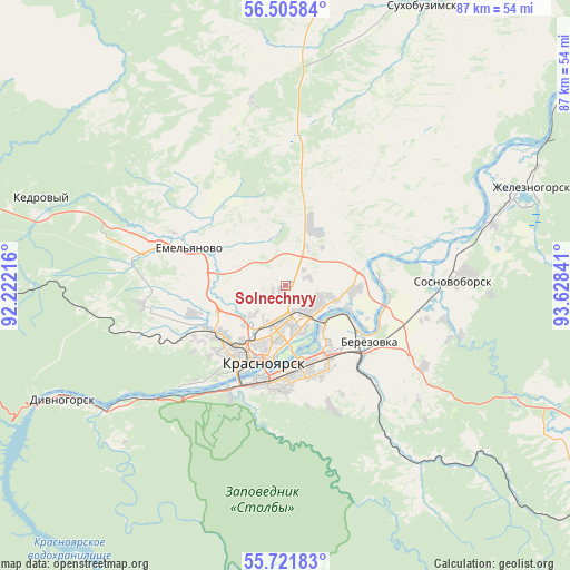
Solnechnyy GPS coordinates[2]
56° 6' 56.988" North, 92° 55' 31.008" East
| Map corner | latitude | longitude |
|---|---|---|
| Upper-left | 56.50584°, | 92.22216° |
| Center: | 56.11583°, | 92.92528° |
| Lower-right: | 55.72183°, | 93.62841° |
| Map W x H: | 87.2×87.2 km | = 54.2×54.2mi |
| max Lat: | 73.50819° ⇑31.9% North |
| Solnechnyy: | 56.11583° |
| min Lat: | ⇓68.1% South 41.28413° |
| min Long | Solnechnyy | max Long |
| -179.12198° | 92.92528° | 179.35046° |
| W 86.6%⇐ | ⇒13.4% E |
Elevation
Elevation of Solnechnyy is 315 m = 1033 ft, and this is 112.4 m = 369 ft above average elevation for this country.
| Max E: |
2518 m = 8261 ft | 15.3% |
| Solnechnyy | 315 m 1033 ft | |
| Avg. | 202.6 m = 665 ft | |
Min E: |
-28 m = -92 ft | 84.7% |
See also: Russia elevation on elevation.city.
Geographical zone
Solnechnyy is located in North temperate zone (between Tropic of Cancer and the Arctic Circle). Distance of this North polar circle is 1161.7 km =721.8 mi to North.| Distance of | km | miles | from Solnechnyy |
|---|---|---|---|
| North Pole | 3767.6 | 2341.1 | to North |
| Arctic Circle | 1161.7 | 721.8 | to North |
| Tropic Cancer | 3633.6 | 2257.8 | to South |
| Equator | 6239.5 | 3877 | to South |


Nearby cities:
15 places around Solnechnyy: (largest is in red/bold)
• Berëzovka
15 km =9.3 mi,  129°
129°
• Divnogorsk
38.6 km =24 mi,  242°
242°
• Kedrovyy
87.8 km =54.6 mi,  282°
282°
• Krasnoyarsk
11.4 km =7.1 mi,  198°
198°
• Ovsyanka
28.1 km =17.5 mi,  231°
231°
• Partizanskoye
114.6 km =71.2 mi, 126°
• Predivinsk
109.9 km =68.3 mi,  16°
16°
• Shalinskoye
68.1 km =42.3 mi, 130°
• Sosnovoborsk
25.6 km =15.9 mi,  88°
88°
• Sukhobuzimskoye
47.8 km =29.7 mi,  26°
26°
• Uyar
93.4 km =58 mi,  111°
111°
• Yemel’yanovo
16.5 km =10.3 mi,  290°
290°
• Zelenogorsk
103.7 km =64.4 mi, 90°
• Zheleznogorsk
40.4 km =25.1 mi,  68°
68°
• Zykovo
23.1 km =14.4 mi,  140°
140°
Sources, notices
• [Note1] Compared only with cities in Russia existing in our database
• [Src1] Map data: © OpenStreetMap contributors (CC-BY-SA)
• [Src2] Other city data from geonames.org with taken over terms of usage.
• [Src3] Geographical zone / Annual Mean Temperature by Robert A. Rohde @ Wikipedia
