Anse Boileau geodata
Anse Boileau is a seat of a first-order administrative division; located in Seychelles in Indian/Mahe (GMT+4) time zone. With population of 4,183 people, there is 1 city with bigger population in this country. Compared to other cities in Seychelles, 75% of cities are located further ↑North; 50% of cities are located further ←West and 100% of cities have higher elevation than Anse Boileau. Note1


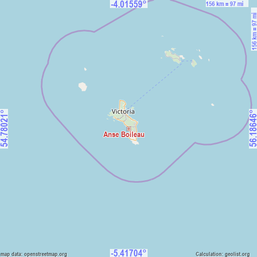
Anse Boileau GPS coordinates[2]
4° 43' 0.012" South, 55° 28' 59.988" East
| Map corner | latitude | longitude |
|---|---|---|
| Upper-left | -4.01559°, | 54.78021° |
| Center: | -4.71667°, | 55.48333° |
| Lower-right: | -5.41704°, | 56.18646° |
| Map W x H: | 155.8×155.8 km | = 96.8×96.8mi |
| max Lat: | -4.34808° ⇑75% North |
| Anse Boileau: | -4.71667° |
| min Lat: | ⇓25% South -4.76667° |
| min Long | Anse Boileau | max Long |
| 55.41667° | 55.48333° | 55.83269° |
| W 50%⇐ | ⇒50% E |
Elevation
Elevation of Anse Boileau is 3 m = 10 ft, and this is 54.6 m = 179 ft below average elevation for this country.
| Max E: |
272 m = 892 ft | 100% |
| Avg. | 57.6 m = 189 ft | |
| Anse Boileau | 3 m = 10 ft | |
Min E: |
3 m = 10 ft | 0% |
See also: Seychelles elevation on elevation.city.
Geographical zone
Anse Boileau is located in South Torrid zone (between Equator and Tropic of Capricorn). Distance of Equator is 524.4 km =325.8 mi to North.| Distance of | km | miles | from Anse Boileau |
|---|---|---|---|
| Equator | 524.4 | 325.8 | to North |
| Tropic Capricorn | 2081.5 | 1293.4 | to South |
| Antarctic Circle | 6876.7 | 4273 | to South |
| South Pole | 9482.6 | 5892.2 | to South |


Nearby cities:
8 places around Anse Boileau: (largest is in red/bold)
• Anse Royale
4.1 km =2.5 mi,  116°
116°
• Beau Vallon
12.2 km =7.6 mi,  331°
331°
• Bel Ombre
13.3 km =8.3 mi, 326°
• Cascade
5.9 km =3.7 mi,  18°
18°
• La Passe
56.4 km =35 mi,  43°
43°
• Port Glaud
9.2 km =5.7 mi,  306°
306°
• Takamaka
5.9 km =3.7 mi,  161°
161°
• Victoria
11.2 km =7 mi,  343°
343°
Sources, notices
• [Note1] Compared only with cities in Seychelles existing in our database
• [Src1] Map data: © OpenStreetMap contributors (CC-BY-SA)
• [Src2] Other city data from geonames.org with taken over terms of usage.
• [Src3] Geographical zone / Annual Mean Temperature by Robert A. Rohde @ Wikipedia
