Lidingö geodata
Lidingö (Stockholm) is a seat of a second-order administrative division; located in Sweden in Europe/Stockholm (GMT+2) time zone. With population of 42,466 people, there are 33 cities with bigger population in this country. Compared to other cities in Sweden, 62.6% of cities are located further ↓South; 87.4% of cities are located further ←West and 65.3% of cities have higher elevation than Lidingö. Note1


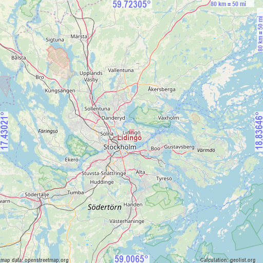
Lidingö GPS coordinates[2]
59° 22' 0.012" North, 18° 7' 59.988" East
| Map corner | latitude | longitude |
|---|---|---|
| Upper-left | 59.72305°, | 17.43021° |
| Center: | 59.36667°, | 18.13333° |
| Lower-right: | 59.0065°, | 18.83646° |
| Map W x H: | 79.7×79.7 km | = 49.5×49.5mi |
| max Lat: | 67.85572° ⇑37.4% North |
| Lidingö: | 59.36667° |
| min Lat: | ⇓62.6% South 55.34337° |
| min Long | Lidingö | max Long |
| 11.1712° | 18.13333° | 24.13676° |
| W 87.4%⇐ | ⇒12.6% E |
Elevation
Elevation of Lidingö is 30 m = 98 ft, and this is 52.6 m = 173 ft below average elevation for this country.
| Max E: |
663 m = 2175 ft | 65.3% |
| Avg. | 82.6 m = 271 ft | |
| Lidingö | 30 m = 98 ft | |
Min E: |
-1 m = -3 ft | 34.7% |
See also: Lidingö elevation on elevation.city.
Geographical zone
Lidingö is located in North temperate zone (between Tropic of Cancer and the Arctic Circle). Distance of this North polar circle is 800.2 km =497.2 mi to North.| Distance of | km | miles | from Lidingö |
|---|---|---|---|
| North Pole | 3406.1 | 2116.5 | to North |
| Arctic Circle | 800.2 | 497.2 | to North |
| Tropic Cancer | 3995 | 2482.4 | to South |
| Equator | 6601 | 4101.7 | to South |


Nearby cities:
15 places around Lidingö: (largest is in red/bold)
• Bergshamra
5.8 km =3.6 mi,  285°
285°
• Brevik
4.2 km =2.6 mi,  116°
116°
• Djursholm
5.7 km =3.5 mi,  309°
309°
• Enebyberg
8.8 km =5.5 mi,  327°
327°
• Gamla Stan
5.7 km =3.5 mi,  217°
217°
• Hästhagen
7.5 km =4.7 mi,  172°
172°
• Kummelnäs
8.7 km =5.4 mi,  102°
102°
• Kungsholmen
6.5 km =4 mi,  233°
233°
• Nacka
6.5 km =4 mi,  164°
164°
• Råsunda
7.8 km =4.8 mi,  269°
269°
• Solna
7.5 km =4.7 mi,  264°
264°
• Stockholm
5.4 km =3.4 mi, 225°
• Södermalm
6.8 km =4.2 mi,  208°
208°
• Vasastan
5.3 km =3.3 mi,  243°
243°
• Östermalm
4.1 km =2.5 mi, 221°
Sources, notices
• [Note1] Compared only with cities in Sweden existing in our database
• [Src1] Map data: © OpenStreetMap contributors (CC-BY-SA)
• [Src2] Other city data from geonames.org with taken over terms of usage.
• [Src3] Geographical zone / Annual Mean Temperature by Robert A. Rohde @ Wikipedia
