Kungsholmen geodata
Kungsholmen (Stockholm) is a section of populated place; located in Sweden in Europe/Stockholm (GMT+2) time zone. With population of 69,363 people, there are 19 cities with bigger population in this country. Compared to other cities in Sweden, 61.3% of cities are located further ↓South; 86% of cities are located further ←West and 66.2% of cities have higher elevation than Kungsholmen. Note1


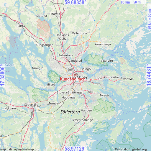
Kungsholmen GPS coordinates[2]
59° 19' 54.588" North, 18° 2' 28.248" East
| Map corner | latitude | longitude |
|---|---|---|
| Upper-left | 59.68858°, | 17.33806° |
| Center: | 59.33183°, | 18.04118° |
| Lower-right: | 58.97129°, | 18.74431° |
| Map W x H: | 79.8×79.8 km | = 49.6×49.6mi |
| max Lat: | 67.85572° ⇑38.7% North |
| Kungsholmen: | 59.33183° |
| min Lat: | ⇓61.3% South 55.34337° |
| min Long | Kungsholmen | max Long |
| 11.1712° | 18.04118° | 24.13676° |
| W 86%⇐ | ⇒14% E |
Elevation
Elevation of Kungsholmen is 28 m = 92 ft, and this is 54.6 m = 179 ft below average elevation for this country.
| Max E: |
663 m = 2175 ft | 66.2% |
| Avg. | 82.6 m = 271 ft | |
| Kungsholmen | 28 m = 92 ft | |
Min E: |
-1 m = -3 ft | 33.8% |
See also: Kungsholmen elevation on elevation.city.
Geographical zone
Kungsholmen is located in North temperate zone (between Tropic of Cancer and the Arctic Circle). Distance of this North polar circle is 804.1 km =499.6 mi to North.| Distance of | km | miles | from Kungsholmen |
|---|---|---|---|
| North Pole | 3410 | 2118.9 | to North |
| Arctic Circle | 804.1 | 499.6 | to North |
| Tropic Cancer | 3991.2 | 2480 | to South |
| Equator | 6597.1 | 4099.2 | to South |


Nearby cities:
15 places around Kungsholmen: (largest is in red/bold)
• Alvik
3.3 km =2.1 mi,  270°
270°
• Bergshamra
5.5 km =3.4 mi,  355°
355°
• Bromma
5.8 km =3.6 mi,  278°
278°
• Gamla Stan
1.9 km =1.2 mi,  109°
109°
• Hästhagen
7.1 km =4.4 mi,  119°
119°
• Lidingö
6.5 km =4 mi,  53°
53°
• Nacka
7.3 km =4.5 mi, 108°
• Råsunda
4.6 km =2.9 mi,  325°
325°
• Solna
3.9 km =2.4 mi,  323°
323°
• Stockholm
1.3 km =0.8 mi,  86°
86°
• Sundbyberg
5.1 km =3.2 mi,  309°
309°
• Södermalm
2.9 km =1.8 mi,  137°
137°
• Vasastan
1.6 km =1 mi,  17°
17°
• Årsta
3.8 km =2.4 mi,  171°
171°
• Östermalm
2.6 km =1.6 mi,  72°
72°
Sources, notices
• [Note1] Compared only with cities in Sweden existing in our database
• [Src1] Map data: © OpenStreetMap contributors (CC-BY-SA)
• [Src2] Other city data from geonames.org with taken over terms of usage.
• [Src3] Geographical zone / Annual Mean Temperature by Robert A. Rohde @ Wikipedia
