Hamrångefjärden geodata
Hamrångefjärden (Gävleborg) is a populated place; located in Sweden in Europe/Stockholm (GMT+2) time zone. With population of 546 people, there are 1243 cities with bigger population in this country. Compared to other cities in Sweden, 82% of cities are located further ↓South; 74.6% of cities are located further ←West and 99.8% of cities have higher elevation than Hamrångefjärden. Note1


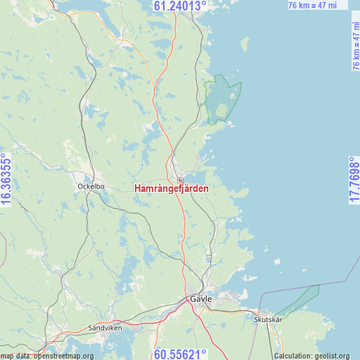
Hamrångefjärden GPS coordinates[2]
60° 54' 0" North, 17° 4' 0.012" East
| Map corner | latitude | longitude |
|---|---|---|
| Upper-left | 61.24013°, | 16.36355° |
| Center: | 60.9°, | 17.06667° |
| Lower-right: | 60.55621°, | 17.7698° |
| Map W x H: | 76×76 km | = 47.2×47.2mi |
| max Lat: | 67.85572° ⇑18% North |
| Hamrångefjärden: | 60.9° |
| min Lat: | ⇓82% South 55.34337° |
| min Long | Hamrångefjärd | max Long |
| 11.1712° | 17.06667° | 24.13676° |
| W 74.6%⇐ | ⇒25.4% E |
Elevation
Elevation of Hamrångefjärden is 1 m = 3 ft, and this is 81.6 m = 268 ft below average elevation for this country.
| Max E: |
663 m = 2175 ft | 99.8% |
| Avg. | 82.6 m = 271 ft | |
| Hamrångefjärden | 1 m = 3 ft | |
Min E: |
-1 m = -3 ft | 0.2% |
See also: Sweden elevation on elevation.city.
Geographical zone
Hamrångefjärden is located in North temperate zone (between Tropic of Cancer and the Arctic Circle). Distance of this North polar circle is 629.7 km =391.3 mi to North.| Distance of | km | miles | from Hamrångefjärden |
|---|---|---|---|
| North Pole | 3235.6 | 2010.5 | to North |
| Arctic Circle | 629.7 | 391.3 | to North |
| Tropic Cancer | 4165.5 | 2588.3 | to South |
| Equator | 6771.4 | 4207.6 | to South |


Nearby cities:
15 places around Hamrångefjärden: (largest is in red/bold)
• Bergby
3.5 km =2.2 mi,  337°
337°
• Björke
16.5 km =10.3 mi,  154°
154°
• Bönan
22.3 km =13.9 mi,  143°
143°
• Forsbacka
33 km =20.5 mi,  197°
197°
• Forsby
20.7 km =12.9 mi,  169°
169°
• Furuvik
31.3 km =19.4 mi, 152°
• Gävle
25.4 km =15.8 mi, 170°
• Järbo
32.5 km =20.2 mi,  231°
231°
• Ljusne
34.8 km =21.6 mi,  5°
5°
• Norrsundet
6.6 km =4.1 mi,  32°
32°
• Ockelbo
18.9 km =11.7 mi,  267°
267°
• Valbo
27.9 km =17.3 mi,  183°
183°
• Åbyggeby
18.7 km =11.6 mi, 171°
• Åbyggeby
22.6 km =14 mi, 274°
• Överhärde
32 km =19.9 mi,  189°
189°
Sources, notices
• [Note1] Compared only with cities in Sweden existing in our database
• [Src1] Map data: © OpenStreetMap contributors (CC-BY-SA)
• [Src2] Other city data from geonames.org with taken over terms of usage.
• [Src3] Geographical zone / Annual Mean Temperature by Robert A. Rohde @ Wikipedia
