Gävle geodata
Gävle (Gävleborg) is a seat of a first-order administrative division; located in Sweden in Europe/Stockholm (GMT+2) time zone. With population of 74,884 people, there are 16 cities with bigger population in this country. Compared to other cities in Sweden, 80.3% of cities are located further ↓South; 75.9% of cities are located further ←West and 97.4% of cities have higher elevation than Gävle. Note1


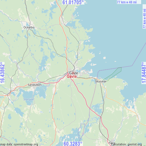
Gävle GPS coordinates[2]
60° 40' 28.272" North, 17° 8' 30.264" East
| Map corner | latitude | longitude |
|---|---|---|
| Upper-left | 61.01705°, | 16.43862° |
| Center: | 60.67452°, | 17.14174° |
| Lower-right: | 60.3283°, | 17.84487° |
| Map W x H: | 76.6×76.6 km | = 47.6×47.6mi |
| max Lat: | 67.85572° ⇑19.7% North |
| Gävle: | 60.67452° |
| min Lat: | ⇓80.3% South 55.34337° |
| min Long | Gävle | max Long |
| 11.1712° | 17.14174° | 24.13676° |
| W 75.9%⇐ | ⇒24.1% E |
Elevation
Elevation of Gävle is 3 m = 10 ft, and this is 79.6 m = 261 ft below average elevation for this country.
| Max E: |
663 m = 2175 ft | 97.4% |
| Avg. | 82.6 m = 271 ft | |
| Gävle | 3 m = 10 ft | |
Min E: |
-1 m = -3 ft | 2.6% |
See also: Gävle elevation on elevation.city.
Geographical zone
Gävle is located in North temperate zone (between Tropic of Cancer and the Arctic Circle). Distance of this North polar circle is 654.8 km =406.9 mi to North.| Distance of | km | miles | from Gävle |
|---|---|---|---|
| North Pole | 3260.7 | 2026.1 | to North |
| Arctic Circle | 654.8 | 406.9 | to North |
| Tropic Cancer | 4140.5 | 2572.8 | to South |
| Equator | 6746.4 | 4192 | to South |


Nearby cities:
15 places around Gävle: (largest is in red/bold)
• Bergby
28.8 km =17.9 mi,  349°
349°
• Björke
10.7 km =6.6 mi,  17°
17°
• Bönan
11.8 km =7.3 mi,  52°
52°
• Forsbacka
15.5 km =9.6 mi,  245°
245°
• Forsby
4.7 km =2.9 mi, 354°
• Furuvik
10.8 km =6.7 mi,  104°
104°
• Hamrångefjärden
25.4 km =15.8 mi, 350°
• Kungsgården
29.8 km =18.5 mi, 253°
• Sandviken
21.4 km =13.3 mi, 252°
• Skutskär
15.9 km =9.9 mi,  110°
110°
• Valbo
6.5 km =4 mi, 245°
• Älvkarleby
20.3 km =12.6 mi,  124°
124°
• Åbyggeby
6.7 km =4.2 mi, 348°
• Årsunda
28.3 km =17.6 mi,  231°
231°
• Överhärde
11.5 km =7.1 mi,  236°
236°
Sources, notices
• [Note1] Compared only with cities in Sweden existing in our database
• [Src1] Map data: © OpenStreetMap contributors (CC-BY-SA)
• [Src2] Other city data from geonames.org with taken over terms of usage.
• [Src3] Geographical zone / Annual Mean Temperature by Robert A. Rohde @ Wikipedia
