Fors geodata
Fors (Västernorrland) is a populated place; located in Sweden in Europe/Stockholm (GMT+2) time zone. With population of 845 people, there are 932 cities with bigger population in this country. Compared to other cities in Sweden, 91.1% of cities are located further ↓South; 91.4% of cities are located further ←West and 79.1% of cities have lower elevation than Fors. Note1


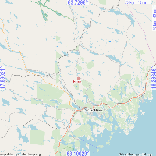
Fors GPS coordinates[2]
63° 25' 0.012" North, 18° 34' 59.988" East
| Map corner | latitude | longitude |
|---|---|---|
| Upper-left | 63.7296°, | 17.88021° |
| Center: | 63.41667°, | 18.58333° |
| Lower-right: | 63.10029°, | 19.28646° |
| Map W x H: | 70×70 km | = 43.5×43.5mi |
| max Lat: | 67.85572° ⇑8.9% North |
| Fors: | 63.41667° |
| min Lat: | ⇓91.1% South 55.34337° |
| min Long | Fors | max Long |
| 11.1712° | 18.58333° | 24.13676° |
| W 91.4%⇐ | ⇒8.6% E |
Elevation
Elevation of Fors is 140 m = 459 ft, and this is 57.4 m = 188 ft above average elevation for this country.
| Max E: |
663 m = 2175 ft | 20.9% |
| Fors | 140 m 459 ft | |
| Avg. | 82.6 m = 271 ft | |
Min E: |
-1 m = -3 ft | 79.1% |
See also: Sweden elevation on elevation.city.
Geographical zone
Fors is located in North temperate zone (between Tropic of Cancer and the Arctic Circle). Distance of this North polar circle is 349.9 km =217.4 mi to North.| Distance of | km | miles | from Fors |
|---|---|---|---|
| North Pole | 2955.8 | 1836.6 | to North |
| Arctic Circle | 349.9 | 217.4 | to North |
| Tropic Cancer | 4445.4 | 2762.2 | to South |
| Equator | 7051.3 | 4381.5 | to South |


Nearby cities:
15 places around Fors: (largest is in red/bold)
• Bjästa
24.4 km =15.2 mi,  189°
189°
• Bredbyn
23.8 km =14.8 mi,  278°
278°
• Fanbyn
31.2 km =19.4 mi,  100°
100°
• Gimåt
13 km =8.1 mi,  149°
149°
• Husum
30.5 km =19 mi,  107°
107°
• Kungsgården
59.7 km =37.1 mi,  219°
219°
• Köpmanholmen
27.8 km =17.3 mi,  181°
181°
• Lögdeå
42.5 km =26.4 mi,  69°
69°
• Mellansel
13.4 km =8.3 mi,  274°
274°
• Nordmaling
48.6 km =30.2 mi, 69°
• Nyland
61.5 km =38.2 mi, 222°
• Rundvik
44.2 km =27.5 mi, 72°
• Torsåker
57.1 km =35.5 mi,  226°
226°
• Örnsköldsvik
15.5 km =9.6 mi, 154°
• Överhörnäs
14.3 km =8.9 mi, 180°
Sources, notices
• [Note1] Compared only with cities in Sweden existing in our database
• [Src1] Map data: © OpenStreetMap contributors (CC-BY-SA)
• [Src2] Other city data from geonames.org with taken over terms of usage.
• [Src3] Geographical zone / Annual Mean Temperature by Robert A. Rohde @ Wikipedia
