Ersmark geodata
Ersmark (Västerbotten) is a populated place; located in Sweden in Europe/Stockholm (GMT+2) time zone. With population of 875 people, there are 899 cities with bigger population in this country. Compared to other cities in Sweden, 95.2% of cities are located further ↓South; 96.4% of cities are located further ←West and 63.9% of cities have higher elevation than Ersmark. Note1


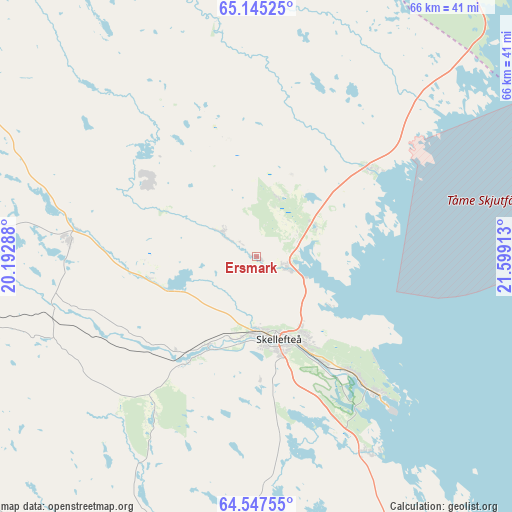
Ersmark GPS coordinates[2]
64° 50' 53.016" North, 20° 53' 45.6" East
| Map corner | latitude | longitude |
|---|---|---|
| Upper-left | 65.14525°, | 20.19288° |
| Center: | 64.84806°, | 20.896° |
| Lower-right: | 64.54755°, | 21.59913° |
| Map W x H: | 66.5×66.5 km | = 41.3×41.3mi |
| max Lat: | 67.85572° ⇑4.8% North |
| Ersmark: | 64.84806° |
| min Lat: | ⇓95.2% South 55.34337° |
| min Long | Ersmark | max Long |
| 11.1712° | 20.896° | 24.13676° |
| W 96.4%⇐ | ⇒3.6% E |
Elevation
Elevation of Ersmark is 31 m = 102 ft, and this is 51.6 m = 169 ft below average elevation for this country.
| Max E: |
663 m = 2175 ft | 63.9% |
| Avg. | 82.6 m = 271 ft | |
| Ersmark | 31 m = 102 ft | |
Min E: |
-1 m = -3 ft | 36.1% |
See also: Sweden elevation on elevation.city.
Geographical zone
Ersmark is located in North temperate zone (between Tropic of Cancer and the Arctic Circle). Distance of this North polar circle is 190.7 km =118.5 mi to North.| Distance of | km | miles | from Ersmark |
|---|---|---|---|
| North Pole | 2796.6 | 1737.7 | to North |
| Arctic Circle | 190.7 | 118.5 | to North |
| Tropic Cancer | 4604.5 | 2861.1 | to South |
| Equator | 7210.4 | 4480.3 | to South |


Nearby cities:
15 places around Ersmark: (largest is in red/bold)
• Backa
17.1 km =10.6 mi,  28°
28°
• Boliden
24.3 km =15.1 mi,  274°
274°
• Byske
18.7 km =11.6 mi,  51°
51°
• Forsbacka
20.8 km =12.9 mi,  244°
244°
• Kåge
4.4 km =2.7 mi,  108°
108°
• Medle
14.5 km =9 mi,  212°
212°
• Nyland
7 km =4.3 mi, 240°
• Ostvik
9 km =5.6 mi,  64°
64°
• Skelleftehamn
24.3 km =15.1 mi,  138°
138°
• Skellefteå
11.2 km =7 mi,  166°
166°
• Stensjön
17.9 km =11.1 mi, 32°
• Svartå
21.5 km =13.4 mi,  343°
343°
• Tällberg
15.7 km =9.8 mi, 343°
• Ursviken
19.8 km =12.3 mi, 139°
• Viken
13.6 km =8.5 mi,  176°
176°
Sources, notices
• [Note1] Compared only with cities in Sweden existing in our database
• [Src1] Map data: © OpenStreetMap contributors (CC-BY-SA)
• [Src2] Other city data from geonames.org with taken over terms of usage.
• [Src3] Geographical zone / Annual Mean Temperature by Robert A. Rohde @ Wikipedia
