Boliden geodata
Boliden (Västerbotten) is a populated place; located in Sweden in Europe/Stockholm (GMT+2) time zone. With population of 1,661 people, there are 606 cities with bigger population in this country. Compared to other cities in Sweden, 95.3% of cities are located further ↓South; 94.9% of cities are located further ←West and 92.6% of cities have lower elevation than Boliden. Note1


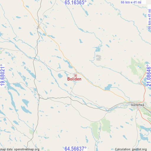
Boliden GPS coordinates[2]
64° 52' 0.012" North, 20° 22' 59.988" East
| Map corner | latitude | longitude |
|---|---|---|
| Upper-left | 65.16365°, | 19.68021° |
| Center: | 64.86667°, | 20.38333° |
| Lower-right: | 64.56637°, | 21.08646° |
| Map W x H: | 66.4×66.4 km | = 41.3×41.3mi |
| max Lat: | 67.85572° ⇑4.7% North |
| Boliden: | 64.86667° |
| min Lat: | ⇓95.3% South 55.34337° |
| min Long | Boliden | max Long |
| 11.1712° | 20.38333° | 24.13676° |
| W 94.9%⇐ | ⇒5.1% E |
Elevation
Elevation of Boliden is 226 m = 741 ft, and this is 143.4 m = 470 ft above average elevation for this country.
| Max E: |
663 m = 2175 ft | 7.4% |
| Boliden | 226 m 741 ft | |
| Avg. | 82.6 m = 271 ft | |
Min E: |
-1 m = -3 ft | 92.6% |
See also: Sweden elevation on elevation.city.
Geographical zone
Boliden is located in North temperate zone (between Tropic of Cancer and the Arctic Circle). Distance of this North polar circle is 188.7 km =117.3 mi to North.| Distance of | km | miles | from Boliden |
|---|---|---|---|
| North Pole | 2794.6 | 1736.5 | to North |
| Arctic Circle | 188.7 | 117.3 | to North |
| Tropic Cancer | 4606.6 | 2862.4 | to South |
| Equator | 7212.5 | 4481.6 | to South |


Nearby cities:
15 places around Boliden: (largest is in red/bold)
• Backa
34.7 km =21.6 mi,  68°
68°
• Ersmark
24.3 km =15.1 mi,  94°
94°
• Forsbacka
12.4 km =7.7 mi,  153°
153°
• Jörn
26.8 km =16.7 mi,  322°
322°
• Kåge
28.6 km =17.8 mi,  96°
96°
• Långsele
8.4 km =5.2 mi,  228°
228°
• Medle
21.8 km =13.5 mi,  130°
130°
• Nyland
19 km =11.8 mi,  107°
107°
• Ostvik
32.3 km =20.1 mi, 86°
• Skellefteå
29.9 km =18.6 mi,  115°
115°
• Stensjön
36.2 km =22.5 mi, 68°
• Storvik
35.5 km =22.1 mi,  27°
27°
• Svartå
25.9 km =16.1 mi,  44°
44°
• Tällberg
23.5 km =14.6 mi,  56°
56°
• Viken
29.7 km =18.5 mi, 121°
Sources, notices
• [Note1] Compared only with cities in Sweden existing in our database
• [Src1] Map data: © OpenStreetMap contributors (CC-BY-SA)
• [Src2] Other city data from geonames.org with taken over terms of usage.
• [Src3] Geographical zone / Annual Mean Temperature by Robert A. Rohde @ Wikipedia
