Vrtojba geodata
Vrtojba (Šempeter-Vrtojba) is a populated place; located in Slovenia in Europe/Ljubljana (GMT+2) time zone. With population of 2,591 people, there are 76 cities with bigger population in this country. Compared to other cities in Slovenia, 82% of cities are located further ↑North; 97.8% of cities are located further →East and 96.8% of cities have higher elevation than Vrtojba. Note1


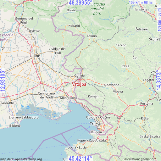
Vrtojba GPS coordinates[2]
45° 54' 45" North, 13° 38' 3.012" East
| Map corner | latitude | longitude |
|---|---|---|
| Upper-left | 46.39955°, | 12.93105° |
| Center: | 45.9125°, | 13.63417° |
| Lower-right: | 45.42114°, | 14.3373° |
| Map W x H: | 108.8×108.8 km | = 67.6×67.6mi |
| max Lat: | 46.83694° ⇑82% North |
| Vrtojba: | 45.9125° |
| min Lat: | ⇓18% South 45.47667° |
| min Long | Vrtojba | max Long |
| 13.52639° | 13.63417° | 16.4975° |
| W 2.2%⇐ | ⇒97.8% E |
Elevation
Elevation of Vrtojba is 61 m = 200 ft, and this is 264.6 m = 868 ft below average elevation for this country.
| Max E: |
1551 m = 5089 ft | 96.8% |
| Avg. | 325.6 m = 1068 ft | |
| Vrtojba | 61 m = 200 ft | |
Min E: |
2 m = 7 ft | 3.2% |
See also: Slovenia elevation on elevation.city.
Geographical zone
Vrtojba is located in North temperate zone (between Tropic of Cancer and the Arctic Circle). Distance of this North polar circle is 2296.2 km =1426.8 mi to North.| Distance of | km | miles | from Vrtojba |
|---|---|---|---|
| North Pole | 4902.1 | 3046 | to North |
| Arctic Circle | 2296.2 | 1426.8 | to North |
| Tropic Cancer | 2499.1 | 1552.9 | to South |
| Equator | 5105 | 3172.1 | to South |


Nearby cities:
15 places around Vrtojba: (largest is in red/bold)
• Bilje
2 km =1.2 mi,  184°
184°
• Dornberk
8.3 km =5.2 mi,  107°
107°
• Gradišče nad Prvačino
5.8 km =3.6 mi,  116°
116°
• Kromberk
5.9 km =3.7 mi,  24°
24°
• Miren
2.8 km =1.7 mi,  227°
227°
• Nova Gorica
5 km =3.1 mi,  12°
12°
• Ozeljan
8.2 km =5.1 mi,  65°
65°
• Prvačina
7 km =4.3 mi, 111°
• Renče
3.7 km =2.3 mi,  133°
133°
• Rožna Dolina
4.2 km =2.6 mi,  38°
38°
• Solkan
6.7 km =4.2 mi, 10°
• Vogrsko
5.2 km =3.2 mi,  97°
97°
• Volčja Draga
3.4 km =2.1 mi, 100°
• Šempas
8.7 km =5.4 mi,  76°
76°
• Šempeter pri Gorici
1.8 km =1.1 mi, 17°
Sources, notices
• [Note1] Compared only with cities in Slovenia existing in our database
• [Src1] Map data: © OpenStreetMap contributors (CC-BY-SA)
• [Src2] Other city data from geonames.org with taken over terms of usage.
• [Src3] Geographical zone / Annual Mean Temperature by Robert A. Rohde @ Wikipedia
