Miren geodata
Miren (Miren-Kostanjevica) is a seat of a first-order administrative division; located in Slovenia in Europe/Ljubljana (GMT+2) time zone. With population of 1,460 people, there are 147 cities with bigger population in this country. Compared to other cities in Slovenia, 83.7% of cities are located further ↑North; 98.8% of cities are located further →East and 97.7% of cities have higher elevation than Miren. Note1


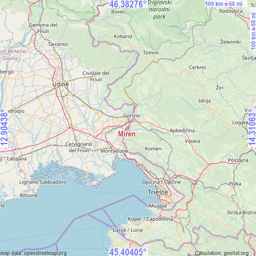
Miren GPS coordinates[2]
45° 53' 44.016" North, 13° 36' 27" East
| Map corner | latitude | longitude |
|---|---|---|
| Upper-left | 46.38276°, | 12.90438° |
| Center: | 45.89556°, | 13.6075° |
| Lower-right: | 45.40405°, | 14.31063° |
| Map W x H: | 108.8×108.8 km | = 67.6×67.6mi |
| max Lat: | 46.83694° ⇑83.7% North |
| Miren: | 45.89556° |
| min Lat: | ⇓16.3% South 45.47667° |
| min Long | Miren | max Long |
| 13.52639° | 13.6075° | 16.4975° |
| W 1.2%⇐ | ⇒98.8% E |
Elevation
Elevation of Miren is 52 m = 171 ft, and this is 273.6 m = 898 ft below average elevation for this country.
| Max E: |
1551 m = 5089 ft | 97.7% |
| Avg. | 325.6 m = 1068 ft | |
| Miren | 52 m = 171 ft | |
Min E: |
2 m = 7 ft | 2.3% |
See also: Slovenia elevation on elevation.city.
Geographical zone
Miren is located in North temperate zone (between Tropic of Cancer and the Arctic Circle). Distance of this North polar circle is 2298.1 km =1428 mi to North.| Distance of | km | miles | from Miren |
|---|---|---|---|
| North Pole | 4904 | 3047.2 | to North |
| Arctic Circle | 2298.1 | 1428 | to North |
| Tropic Cancer | 2497.2 | 1551.7 | to South |
| Equator | 5103.1 | 3170.9 | to South |


Nearby cities:
15 places around Miren: (largest is in red/bold)
• Bilje
1.9 km =1.2 mi,  93°
93°
• Dornberk
10 km =6.2 mi, 93°
• Gradišče nad Prvačino
7.3 km =4.5 mi,  95°
95°
• Kromberk
8.5 km =5.3 mi,  31°
31°
• Nova Gorica
7.4 km =4.6 mi, 25°
• Ozeljan
10.9 km =6.8 mi,  60°
60°
• Prvačina
8.6 km =5.3 mi, 94°
• Renče
4.8 km =3 mi, 97°
• Rožna Dolina
7 km =4.3 mi,  42°
42°
• Solkan
9 km =5.6 mi,  21°
21°
• Vogrsko
7.3 km =4.5 mi,  80°
80°
• Volčja Draga
5.6 km =3.5 mi, 76°
• Vrtojba
2.8 km =1.7 mi,  47°
47°
• Šempas
11.2 km =7 mi,  69°
69°
• Šempeter pri Gorici
4.4 km =2.7 mi, 36°
Sources, notices
• [Note1] Compared only with cities in Slovenia existing in our database
• [Src1] Map data: © OpenStreetMap contributors (CC-BY-SA)
• [Src2] Other city data from geonames.org with taken over terms of usage.
• [Src3] Geographical zone / Annual Mean Temperature by Robert A. Rohde @ Wikipedia
