Strahinj geodata
Strahinj (Naklo) is a populated place; located in Slovenia in Europe/Ljubljana (GMT+2) time zone. With population of 765 people, there are 322 cities with bigger population in this country. Compared to other cities in Slovenia, 52.7% of cities are located further ↓South; 75.7% of cities are located further →East and 78% of cities have lower elevation than Strahinj. Note1


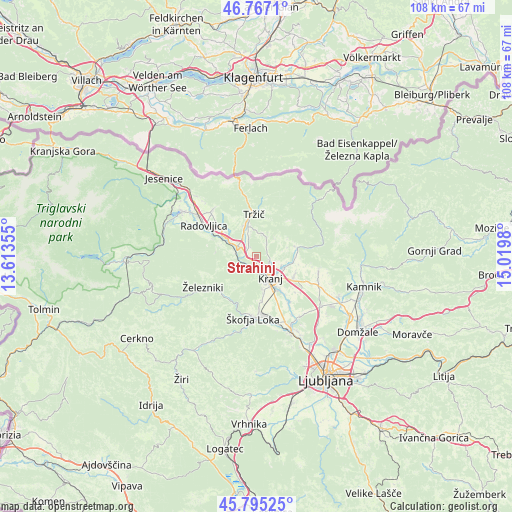
Strahinj GPS coordinates[2]
46° 16' 59.988" North, 14° 19' 0.012" East
| Map corner | latitude | longitude |
|---|---|---|
| Upper-left | 46.7671°, | 13.61355° |
| Center: | 46.28333°, | 14.31667° |
| Lower-right: | 45.79525°, | 15.0198° |
| Map W x H: | 108.1×108.1 km | = 67.2×67.2mi |
| max Lat: | 46.83694° ⇑47.3% North |
| Strahinj: | 46.28333° |
| min Lat: | ⇓52.7% South 45.47667° |
| min Long | Strahinj | max Long |
| 13.52639° | 14.31667° | 16.4975° |
| W 24.3%⇐ | ⇒75.7% E |
Elevation
Elevation of Strahinj is 417 m = 1368 ft, and this is 91.4 m = 300 ft above average elevation for this country.
| Max E: |
1551 m = 5089 ft | 22% |
| Strahinj | 417 m 1368 ft | |
| Avg. | 325.6 m = 1068 ft | |
Min E: |
2 m = 7 ft | 78% |
See also: Slovenia elevation on elevation.city.
Geographical zone
Strahinj is located in North temperate zone (between Tropic of Cancer and the Arctic Circle). Distance of this North polar circle is 2255 km =1401.2 mi to North.| Distance of | km | miles | from Strahinj |
|---|---|---|---|
| North Pole | 4860.8 | 3020.4 | to North |
| Arctic Circle | 2255 | 1401.2 | to North |
| Tropic Cancer | 2540.3 | 1578.5 | to South |
| Equator | 5146.2 | 3197.7 | to South |


Nearby cities:
15 places around Strahinj: (largest is in red/bold)
• Britof
6.2 km =3.9 mi,  114°
114°
• Golnik
5.7 km =3.5 mi,  12°
12°
• Kokrica
3.7 km =2.3 mi, 113°
• Kranj
5.8 km =3.6 mi,  148°
148°
• Križe
6.7 km =4.2 mi,  349°
349°
• Mlaka pri Kranju
2.6 km =1.6 mi,  90°
90°
• Naklo
1.2 km =0.7 mi,  177°
177°
• Podbrezje
3.2 km =2 mi,  305°
305°
• Predoslje
5.7 km =3.5 mi, 110°
• Pristava
7.4 km =4.6 mi, 350°
• Spodnja Besnica
3 km =1.9 mi,  196°
196°
• Spodnje Duplje
2.3 km =1.4 mi,  325°
325°
• Zgornja Besnica
3.2 km =2 mi,  234°
234°
• Zgornje Bitnje
7.2 km =4.5 mi,  167°
167°
• Zgornje Duplje
3.3 km =2.1 mi,  323°
323°
Sources, notices
• [Note1] Compared only with cities in Slovenia existing in our database
• [Src1] Map data: © OpenStreetMap contributors (CC-BY-SA)
• [Src2] Other city data from geonames.org with taken over terms of usage.
• [Src3] Geographical zone / Annual Mean Temperature by Robert A. Rohde @ Wikipedia
