Predoslje geodata
Predoslje (Kranj) is a populated place; located in Slovenia in Europe/Ljubljana (GMT+2) time zone. With population of 989 people, there are 220 cities with bigger population in this country. Compared to other cities in Slovenia, 50.5% of cities are located further ↓South; 72.3% of cities are located further →East and 78.5% of cities have lower elevation than Predoslje. Note1


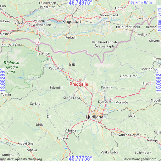
Predoslje GPS coordinates[2]
46° 15' 56.952" North, 14° 23' 9.888" East
| Map corner | latitude | longitude |
|---|---|---|
| Upper-left | 46.74975°, | 13.68296° |
| Center: | 46.26582°, | 14.38608° |
| Lower-right: | 45.77758°, | 15.08921° |
| Map W x H: | 108.1×108.1 km | = 67.2×67.2mi |
| max Lat: | 46.83694° ⇑49.5% North |
| Predoslje: | 46.26582° |
| min Lat: | ⇓50.5% South 45.47667° |
| min Long | Predoslje | max Long |
| 13.52639° | 14.38608° | 16.4975° |
| W 27.7%⇐ | ⇒72.3% E |
Elevation
Elevation of Predoslje is 419 m = 1375 ft, and this is 93.4 m = 306 ft above average elevation for this country.
| Max E: |
1551 m = 5089 ft | 21.5% |
| Predoslje | 419 m 1375 ft | |
| Avg. | 325.6 m = 1068 ft | |
Min E: |
2 m = 7 ft | 78.5% |
See also: Slovenia elevation on elevation.city.
Geographical zone
Predoslje is located in North temperate zone (between Tropic of Cancer and the Arctic Circle). Distance of this North polar circle is 2256.9 km =1402.4 mi to North.| Distance of | km | miles | from Predoslje |
|---|---|---|---|
| North Pole | 4862.8 | 3021.6 | to North |
| Arctic Circle | 2256.9 | 1402.4 | to North |
| Tropic Cancer | 2538.4 | 1577.3 | to South |
| Equator | 5144.3 | 3196.5 | to South |


Nearby cities:
15 places around Predoslje: (largest is in red/bold)
• Britof
0.7 km =0.4 mi,  152°
152°
• Hotemaže
3.2 km =2 mi,  57°
57°
• Hrastje
5.6 km =3.5 mi,  168°
168°
• Kokrica
2 km =1.2 mi,  284°
284°
• Kranj
3.8 km =2.4 mi,  218°
218°
• Mlaka pri Kranju
3.4 km =2.1 mi,  305°
305°
• Naklo
5.3 km =3.3 mi, 278°
• Preddvor
5 km =3.1 mi,  34°
34°
• Spodnja Besnica
6.2 km =3.9 mi,  261°
261°
• Srednje Bitnje
6.8 km =4.2 mi, 216°
• Strahinj
5.7 km =3.5 mi,  290°
290°
• Visoko
2.5 km =1.6 mi,  76°
76°
• Voklo
6.2 km =3.9 mi, 152°
• Zgornje Bitnje
6.4 km =4 mi, 216°
• Šenčur
3.4 km =2.1 mi,  131°
131°
Sources, notices
• [Note1] Compared only with cities in Slovenia existing in our database
• [Src1] Map data: © OpenStreetMap contributors (CC-BY-SA)
• [Src2] Other city data from geonames.org with taken over terms of usage.
• [Src3] Geographical zone / Annual Mean Temperature by Robert A. Rohde @ Wikipedia
