Polica geodata
Polica (Grosuplje) is a populated place; located in Slovenia in Europe/Ljubljana (GMT+2) time zone. With population of 720 people, there are 347 cities with bigger population in this country. Compared to other cities in Slovenia, 75% of cities are located further ↑North; 56.7% of cities are located further →East and 79.7% of cities have lower elevation than Polica. Note1


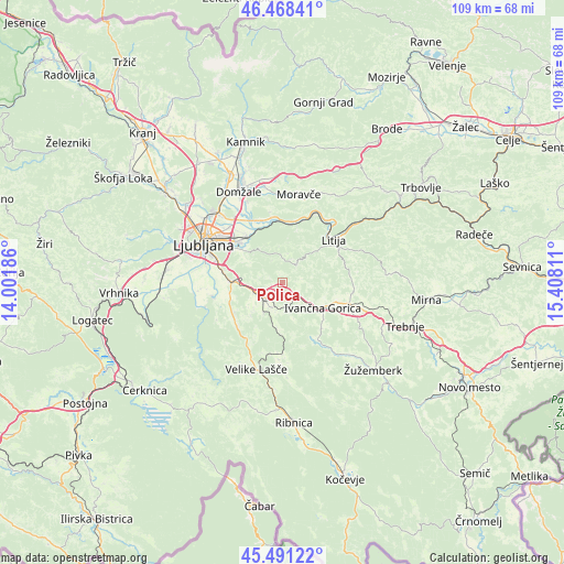
Polica GPS coordinates[2]
45° 58' 55.092" North, 14° 42' 17.928" East
| Map corner | latitude | longitude |
|---|---|---|
| Upper-left | 46.46841°, | 14.00186° |
| Center: | 45.98197°, | 14.70498° |
| Lower-right: | 45.49122°, | 15.40811° |
| Map W x H: | 108.7×108.7 km | = 67.5×67.5mi |
| max Lat: | 46.83694° ⇑75% North |
| Polica: | 45.98197° |
| min Lat: | ⇓25% South 45.47667° |
| min Long | Polica | max Long |
| 13.52639° | 14.70498° | 16.4975° |
| W 43.3%⇐ | ⇒56.7% E |
Elevation
Elevation of Polica is 434 m = 1424 ft, and this is 108.4 m = 356 ft above average elevation for this country.
| Max E: |
1551 m = 5089 ft | 20.3% |
| Polica | 434 m 1424 ft | |
| Avg. | 325.6 m = 1068 ft | |
Min E: |
2 m = 7 ft | 79.7% |
See also: Slovenia elevation on elevation.city.
Geographical zone
Polica is located in North temperate zone (between Tropic of Cancer and the Arctic Circle). Distance of this North polar circle is 2288.5 km =1422 mi to North.| Distance of | km | miles | from Polica |
|---|---|---|---|
| North Pole | 4894.3 | 3041.2 | to North |
| Arctic Circle | 2288.5 | 1422 | to North |
| Tropic Cancer | 2506.8 | 1557.7 | to South |
| Equator | 5112.7 | 3176.9 | to South |


Nearby cities:
15 places around Polica: (largest is in red/bold)
• Brezje pri Grosupljem
6 km =3.7 mi,  234°
234°
• Gradišče
11.3 km =7 mi, 233°
• Grosuplje
4.6 km =2.9 mi, 230°
• Ivančna Gorica
9.1 km =5.7 mi,  122°
122°
• Lavrica
11.6 km =7.2 mi,  279°
279°
• Pijava Gorica
10.8 km =6.7 mi,  251°
251°
• Ponova Vas
7.4 km =4.6 mi, 228°
• Smrjene
10 km =6.2 mi,  240°
240°
• Spodnja Slivnica
7.4 km =4.6 mi,  209°
209°
• Stična
8.5 km =5.3 mi,  106°
106°
• Veliko Mlačevo
5.3 km =3.3 mi,  199°
199°
• Višnja Gora
4.4 km =2.7 mi,  135°
135°
• Šentvid pri Stični
11.3 km =7 mi, 108°
• Škofljica
9.9 km =6.2 mi,  270°
270°
• Šmarje-Sap
7.2 km =4.5 mi,  264°
264°
Sources, notices
• [Note1] Compared only with cities in Slovenia existing in our database
• [Src1] Map data: © OpenStreetMap contributors (CC-BY-SA)
• [Src2] Other city data from geonames.org with taken over terms of usage.
• [Src3] Geographical zone / Annual Mean Temperature by Robert A. Rohde @ Wikipedia
