Škofljica geodata
Škofljica is a seat of a first-order administrative division; located in Slovenia in Europe/Ljubljana (GMT+2) time zone. With population of 2,209 people, there are 88 cities with bigger population in this country. Compared to other cities in Slovenia, 74.8% of cities are located further ↑North; 63.8% of cities are located further →East and 52.5% of cities have lower elevation than Škofljica. Note1


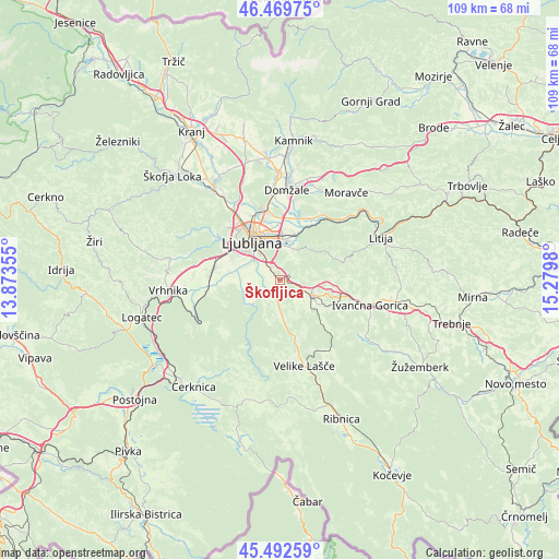
Škofljica GPS coordinates[2]
45° 58' 59.988" North, 14° 34' 36.012" East
| Map corner | latitude | longitude |
|---|---|---|
| Upper-left | 46.46975°, | 13.87355° |
| Center: | 45.98333°, | 14.57667° |
| Lower-right: | 45.49259°, | 15.2798° |
| Map W x H: | 108.7×108.6 km | = 67.5×67.5mi |
| max Lat: | 46.83694° ⇑74.8% North |
| Škofljica: | 45.98333° |
| min Lat: | ⇓25.2% South 45.47667° |
| min Long | Škofljica | max Long |
| 13.52639° | 14.57667° | 16.4975° |
| W 36.2%⇐ | ⇒63.8% E |
Elevation
Elevation of Škofljica is 302 m = 991 ft, and this is 23.6 m = 77 ft below average elevation for this country.
| Max E: |
1551 m = 5089 ft | 47.5% |
| Avg. | 325.6 m = 1068 ft | |
| Škofljica | 302 m = 991 ft | |
Min E: |
2 m = 7 ft | 52.5% |
See also: Slovenia elevation on elevation.city.
Geographical zone
Škofljica is located in North temperate zone (between Tropic of Cancer and the Arctic Circle). Distance of this North polar circle is 2288.3 km =1421.9 mi to North.| Distance of | km | miles | from Škofljica |
|---|---|---|---|
| North Pole | 4894.2 | 3041.1 | to North |
| Arctic Circle | 2288.3 | 1421.9 | to North |
| Tropic Cancer | 2506.9 | 1557.7 | to South |
| Equator | 5112.9 | 3177 | to South |


Nearby cities:
15 places around Škofljica: (largest is in red/bold)
• Brezje pri Grosupljem
6.3 km =3.9 mi,  125°
125°
• Gradišče
6.9 km =4.3 mi,  173°
173°
• Grosuplje
7.1 km =4.4 mi,  115°
115°
• Ig
4.5 km =2.8 mi,  235°
235°
• Jezero
11.2 km =7 mi,  262°
262°
• Lavrica
2.4 km =1.5 mi,  321°
321°
• Ljubljana
9.3 km =5.8 mi, 323°
• Pijava Gorica
3.6 km =2.2 mi,  185°
185°
• Polica
9.9 km =6.2 mi,  90°
90°
• Ponova Vas
6.6 km =4.1 mi,  139°
139°
• Smrjene
5.2 km =3.2 mi, 166°
• Spodnja Slivnica
9.1 km =5.7 mi, 136°
• Veliko Mlačevo
9.6 km =6 mi, 122°
• Črna Vas
8.3 km =5.2 mi,  280°
280°
• Šmarje-Sap
2.8 km =1.7 mi,  106°
106°
Sources, notices
• [Note1] Compared only with cities in Slovenia existing in our database
• [Src1] Map data: © OpenStreetMap contributors (CC-BY-SA)
• [Src2] Other city data from geonames.org with taken over terms of usage.
• [Src3] Geographical zone / Annual Mean Temperature by Robert A. Rohde @ Wikipedia
