Podpeč geodata
Podpeč (Brezovica) is a populated place; located in Slovenia in Europe/Ljubljana (GMT+2) time zone. With population of 529 people, there are 511 cities with bigger population in this country. Compared to other cities in Slovenia, 76.2% of cities are located further ↑North; 69.8% of cities are located further →East and 59.8% of cities have lower elevation than Podpeč. Note1


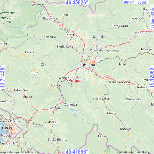
Podpeč GPS coordinates[2]
45° 58' 10.992" North, 14° 25' 3" East
| Map corner | latitude | longitude |
|---|---|---|
| Upper-left | 46.45626°, | 13.71438° |
| Center: | 45.96972°, | 14.4175° |
| Lower-right: | 45.47886°, | 15.12063° |
| Map W x H: | 108.7×108.7 km | = 67.5×67.5mi |
| max Lat: | 46.83694° ⇑76.2% North |
| Podpeč: | 45.96972° |
| min Lat: | ⇓23.8% South 45.47667° |
| min Long | Podpeč | max Long |
| 13.52639° | 14.4175° | 16.4975° |
| W 30.2%⇐ | ⇒69.8% E |
Elevation
Elevation of Podpeč is 326 m = 1070 ft, and this is 0.39999999999998 m = 1 ft above average elevation for this country.
| Max E: |
1551 m = 5089 ft | 40.2% |
| Podpeč | 326 m 1070 ft | |
| Avg. | 325.6 m = 1068 ft | |
Min E: |
2 m = 7 ft | 59.8% |
See also: Slovenia elevation on elevation.city.
Geographical zone
Podpeč is located in North temperate zone (between Tropic of Cancer and the Arctic Circle). Distance of this North polar circle is 2289.8 km =1422.8 mi to North.| Distance of | km | miles | from Podpeč |
|---|---|---|---|
| North Pole | 4895.7 | 3042 | to North |
| Arctic Circle | 2289.8 | 1422.8 | to North |
| Tropic Cancer | 2505.4 | 1556.8 | to South |
| Equator | 5111.4 | 3176.1 | to South |


Nearby cities:
15 places around Podpeč: (largest is in red/bold)
• Bevke
5 km =3.1 mi,  288°
288°
• Borovnica
7.3 km =4.5 mi,  215°
215°
• Brezovica pri Ljubljani
7.2 km =4.5 mi,  349°
349°
• Dobrova
8.7 km =5.4 mi, 346°
• Dragomer
5.8 km =3.6 mi,  333°
333°
• Drenov Grič
7.3 km =4.5 mi,  295°
295°
• Ig
8.7 km =5.4 mi,  96°
96°
• Jezero
1.2 km =0.7 mi,  88°
88°
• Kamnik pod Krimom
2.7 km =1.7 mi,  198°
198°
• Log pri Brezovici
6.5 km =4 mi,  323°
323°
• Lukovica pri Brezovici
5.4 km =3.4 mi,  340°
340°
• Notranje Gorice
2.4 km =1.5 mi, 323°
• Sinja Gorica
7.7 km =4.8 mi,  274°
274°
• Vnanje Gorice
4.2 km =2.6 mi,  4°
4°
• Črna Vas
5.1 km =3.2 mi,  53°
53°
Sources, notices
• [Note1] Compared only with cities in Slovenia existing in our database
• [Src1] Map data: © OpenStreetMap contributors (CC-BY-SA)
• [Src2] Other city data from geonames.org with taken over terms of usage.
• [Src3] Geographical zone / Annual Mean Temperature by Robert A. Rohde @ Wikipedia
