Ig geodata
Ig is a seat of a first-order administrative division; located in Slovenia in Europe/Ljubljana (GMT+2) time zone. With population of 2,262 people, there are 86 cities with bigger population in this country. Compared to other cities in Slovenia, 76.8% of cities are located further ↑North; 65.3% of cities are located further →East and 50.7% of cities have higher elevation than Ig. Note1


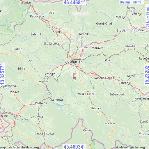
Ig GPS coordinates[2]
45° 57' 37.008" North, 14° 31' 44.004" East
| Map corner | latitude | longitude |
|---|---|---|
| Upper-left | 46.44691°, | 13.82577° |
| Center: | 45.96028°, | 14.52889° |
| Lower-right: | 45.46934°, | 15.23202° |
| Map W x H: | 108.7×108.7 km | = 67.5×67.5mi |
| max Lat: | 46.83694° ⇑76.8% North |
| Ig: | 45.96028° |
| min Lat: | ⇓23.2% South 45.47667° |
| min Long | Ig | max Long |
| 13.52639° | 14.52889° | 16.4975° |
| W 34.7%⇐ | ⇒65.3% E |
Elevation
Elevation of Ig is 295 m = 968 ft, and this is 30.6 m = 100 ft below average elevation for this country.
| Max E: |
1551 m = 5089 ft | 50.7% |
| Avg. | 325.6 m = 1068 ft | |
| Ig | 295 m = 968 ft | |
Min E: |
2 m = 7 ft | 49.3% |
See also: Slovenia elevation on elevation.city.
Geographical zone
Ig is located in North temperate zone (between Tropic of Cancer and the Arctic Circle). Distance of this North polar circle is 2290.9 km =1423.5 mi to North.| Distance of | km | miles | from Ig |
|---|---|---|---|
| North Pole | 4896.8 | 3042.7 | to North |
| Arctic Circle | 2290.9 | 1423.5 | to North |
| Tropic Cancer | 2504.4 | 1556.2 | to South |
| Equator | 5110.3 | 3175.4 | to South |


Nearby cities:
15 places around Ig: (largest is in red/bold)
• Brezje pri Grosupljem
8.8 km =5.5 mi,  97°
97°
• Gradišče
6.2 km =3.9 mi,  133°
133°
• Grosuplje
10.1 km =6.3 mi,  92°
92°
• Jezero
7.5 km =4.7 mi,  278°
278°
• Kamnik pod Krimom
9.6 km =6 mi,  260°
260°
• Lavrica
4.9 km =3 mi,  26°
26°
• Pijava Gorica
3.5 km =2.2 mi,  107°
107°
• Podpeč
8.7 km =5.4 mi, 276°
• Ponova Vas
8.4 km =5.2 mi, 106°
• Rakitna
10.3 km =6.4 mi,  219°
219°
• Smrjene
5.5 km =3.4 mi,  117°
117°
• Vnanje Gorice
9.8 km =6.1 mi,  302°
302°
• Črna Vas
6.1 km =3.8 mi,  312°
312°
• Škofljica
4.5 km =2.8 mi,  55°
55°
• Šmarje-Sap
6.6 km =4.1 mi,  74°
74°
Sources, notices
• [Note1] Compared only with cities in Slovenia existing in our database
• [Src1] Map data: © OpenStreetMap contributors (CC-BY-SA)
• [Src2] Other city data from geonames.org with taken over terms of usage.
• [Src3] Geographical zone / Annual Mean Temperature by Robert A. Rohde @ Wikipedia
