Petrovče geodata
Petrovče (Žalec) is a populated place; located in Slovenia in Europe/Ljubljana (GMT+2) time zone. With population of 973 people, there are 223 cities with bigger population in this country. Compared to other cities in Slovenia, 52.5% of cities are located further ↑North; 60.7% of cities are located further ←West and 67.2% of cities have higher elevation than Petrovče. Note1


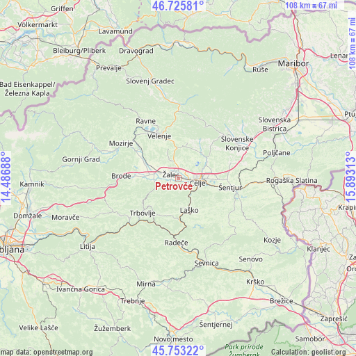
Petrovče GPS coordinates[2]
46° 14' 30.012" North, 15° 11' 24" East
| Map corner | latitude | longitude |
|---|---|---|
| Upper-left | 46.72581°, | 14.48688° |
| Center: | 46.24167°, | 15.19° |
| Lower-right: | 45.75322°, | 15.89313° |
| Map W x H: | 108.1×108.1 km | = 67.2×67.2mi |
| max Lat: | 46.83694° ⇑52.5% North |
| Petrovče: | 46.24167° |
| min Lat: | ⇓47.5% South 45.47667° |
| min Long | Petrovče | max Long |
| 13.52639° | 15.19° | 16.4975° |
| W 60.7%⇐ | ⇒39.3% E |
Elevation
Elevation of Petrovče is 249 m = 817 ft, and this is 76.6 m = 251 ft below average elevation for this country.
| Max E: |
1551 m = 5089 ft | 67.2% |
| Avg. | 325.6 m = 1068 ft | |
| Petrovče | 249 m = 817 ft | |
Min E: |
2 m = 7 ft | 32.8% |
See also: Slovenia elevation on elevation.city.
Geographical zone
Petrovče is located in North temperate zone (between Tropic of Cancer and the Arctic Circle). Distance of this North polar circle is 2259.6 km =1404 mi to North.| Distance of | km | miles | from Petrovče |
|---|---|---|---|
| North Pole | 4865.5 | 3023.3 | to North |
| Arctic Circle | 2259.6 | 1404 | to North |
| Tropic Cancer | 2535.7 | 1575.6 | to South |
| Equator | 5141.6 | 3194.8 | to South |


Nearby cities:
15 places around Petrovče: (largest is in red/bold)
• Arja Vas
1.9 km =1.2 mi,  357°
357°
• Celje
5.5 km =3.4 mi,  102°
102°
• Gorica pri Šmartnem
4.8 km =3 mi,  40°
40°
• Gotovlje
4.7 km =2.9 mi,  320°
320°
• Griže
3.3 km =2.1 mi,  245°
245°
• Kasaze
1.2 km =0.7 mi,  140°
140°
• Košnica pri Celju
4.3 km =2.7 mi,  129°
129°
• Liboje
3.4 km =2.1 mi,  173°
173°
• Lopata
3.7 km =2.3 mi,  55°
55°
• Migojnice
2 km =1.2 mi,  242°
242°
• Pongrac
5.2 km =3.2 mi, 237°
• Vrbje
3.2 km =2 mi,  286°
286°
• Zabukovica
3.9 km =2.4 mi,  217°
217°
• Šempeter v Savinj. Dolini
5.5 km =3.4 mi, 287°
• Žalec
2.2 km =1.4 mi,  299°
299°
Sources, notices
• [Note1] Compared only with cities in Slovenia existing in our database
• [Src1] Map data: © OpenStreetMap contributors (CC-BY-SA)
• [Src2] Other city data from geonames.org with taken over terms of usage.
• [Src3] Geographical zone / Annual Mean Temperature by Robert A. Rohde @ Wikipedia
